11.30.2007 09:03
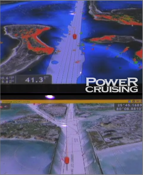
Furuno NavNet3D
I've said this before... This looks like many of the technologies
CCOM/JHC has been talking about for many years (e.g. GeoNav, GeoZui3D,
GeoZui4D, libgz4d, Fledermaus). Nice to see these things hitting the
commercial world.
NavNet 3D, the buzz continues [panbo] - Check out about half way through the video.
NavNet 3D, the buzz continues [panbo] - Check out about half way through the video.
11.30.2007 08:24
Rear Adm. Bone guest blog - SF Cosco Busan
In defense of the Coast Guard [nj.com]
...
The response to the oil spill here was anything but weak and slow as
your editorial asserted. Within 15 minutes Coast Guard pollution
investigators were directed to the scene and they arrived through
heavy fog 28 minutes later.
.
A commercial oil spill response vessel and oil skimmer were underway
within 40 minutes and in less than six hours (the regulatory standard)
nine times the equipment required by law was in use. This response
resulted in the recovery of 8,000 gallons of fuel in the first 10
hours, a remarkable feat given the weather conditions. As of today the
unified response has recovered nearly 30 percent of the spilled fuel,
exceeding the 5-20 percent that is generally recovered.
.
Despite good work by spill response forces on the water, the federal
and state governments could have done much better in communicating
with City of San Francisco officials early on in this incident and
throughout the day.
...
11.30.2007 08:08
NOAA Ports in Mobile Bay
NOAA PORTS Ocean Observing System Installed in Mobile Bay
http://www.tidesandcurrents.noaa.gov/ports
...
The Mobile system brings to 14 the number of PORTS in operation
around the nation. Studies have shown more than a 50 percent decrease
in vessel groundings following the installation of PORTS in other
areas. Estimates of economic benefits directly attributed to PORTS
range from $7 million per year for Tampa Bay to $16 million per year
for Houston-Galveston. The Port of Mobile is the 11th largest in the
United States, handling 24 million tons of cargo in 2006, accounting
for $89.5 million in revenue.
...
http://www.tidesandcurrents.noaa.gov/ports
11.29.2007 17:18
Fun with timestamps in PostgreSQL
I found that this is a pretty nice query, but super slow. The idea of
this query is to count the number of vessels in an area for each day
of the year (doy; see also functions-datetime[sql.org])
Doing just 5 days takes just over 17 seconds. with my small dataset of 4.14 million records. Not good. Now doing the same thing with date ranges is much faster. The following queries take only 0.27s.
select distinct(userid) from position where 2 = EXTRACT(doy FROM cg_timestamp);
  userid
===========
 303388000
 316012950
 366897920
 367075760
 477930000
(5 rows)
I thought maybe my index on the cg_timestamp didn't cross over to my new laptop, but no, it is still there:
\d position
...
Indexes:
    "position_pkey" PRIMARY KEY, btree ("key")
    "cg_timestamp_idx" btree (cg_timestamp)
    "userid_idx" btree (userid)
Doing just 5 days takes just over 17 seconds. with my small dataset of 4.14 million records. Not good. Now doing the same thing with date ranges is much faster. The following queries take only 0.27s.
SELECT count(distinct(userid)) FROM position WHERE cg_timestamp >= '2006-01-01 00:00:00' AND cg_timestamp <= '2006-01-01 23:59:59';
SELECT count(distinct(userid)) FROM position WHERE cg_timestamp >= '2006-01-02 00:00:00' AND cg_timestamp <= '2006-01-02 23:59:59';
SELECT count(distinct(userid)) FROM position WHERE cg_timestamp >= '2006-01-03 00:00:00' AND cg_timestamp <= '2006-01-03 23:59:59';
SELECT count(distinct(userid)) FROM position WHERE cg_timestamp >= '2006-01-04 00:00:00' AND cg_timestamp <= '2006-01-04 23:59:59';
SELECT count(distinct(userid)) FROM position WHERE cg_timestamp >= '2006-01-05 00:00:00' AND cg_timestamp <= '2006-01-05 23:59:59';
Another little fun SQL command:
SELECT now();
              now
==============================
 2007-11-29 17:31:13.825532-05
11.29.2007 13:52
NAIS Incr 2 Synopsis is out!
This is big news!
D -- Nationwide Automatic Identification System (NAIS) Increment 2 Phase 1
D -- Nationwide Automatic Identification System (NAIS) Increment 2 Phase 1
The Office of Contract Operations, Major Systems Acquisition Division,
of the United States Coast Guard (USCG) Headquarters expects to
release Request for Proposal (RFP) No. HSCG23-08-R-ADA011 to procure
Increment 2 Phase I of the Nationwide Automatic Identification System
(NAIS).  The expected release date for the RFP is on or about December
20, 2007.  The USCG contemplates an award of one hybrid type contract.

The NAIS, which uses international standards-based Automatic
Identification System (AIS) technology for ship-to-ship, ship-to-shore
and shore-to-ship communication of navigation information to support
Maritime Domain Awareness (MDA), is being implemented by the USCG
incrementally.  Increment 1, which was completed at the end of FY
2007, is operational and providing receive-only capability in 55
critical ports and 9 coastal areas across the country.  Increment 2,
to be implemented over two phases, will establish coastal transmit and
receive capability nationwide.  Increment 3 will provide long-range
receive capability nationwide.  Phase 2 of Increment 2 and Increment 3
will be the subject of separate procurements.

Increment 2 Phase I, which is the subject of this RFP, involves the
work necessary to design, develop and deliver the core NAIS
capability, achieve NAIS receive and transmit coverage for three
designated Coast Guard Sectors to establish Initial Operational
Capability (IOC); and, to provide systems engineering, physical and
logical shore stations hardware and software, initial logistics, and
Sector coverage design services to support post-IOC deployment towards
achieving Full Operational Capability (FOC) or complete receive and
transmit coverage.

This core system shall provide all of the necessary I-2 functionality
for a fully-capable system, albeit with a limited number of Physical
Shore Stations (PSSs) and Logical Shore Stations (LSSs).  The core
capability of the NAIS, which is a subset of the IOC, is defined as
the following system elements or capabilities:

  ** Centralized storage and enterprise services for the Enterprise
     Data Center (EDC), to include data storage, data retrieval, and
     external data capture services, as well as the interfaces to the
     External Data Providers and External AIS User Systems as
     described in the PSPEC;

  ** The AIS Service Management at the System Operations Center (SOC),
     to include the SOC User Human System Interface as described in
     the PSPEC;

  ** Three Physical Shore Stations (PSSs) ? one at Government
     designated site within Sector Delaware Bay and two at the Coast
     Guard Command and Control Engineering Center (C2CEN);

  ** Two Logical Shore Stations (LSSs) ? functionality to be provided
     at the SOC and C2CEN;

  ** Both the Sector Command Center User and SOC User Human System
     Interface components;

  ** Incorporation of Increment 1 AIS data feeds into the EDC; and

  ** All network functions and capabilities associated with connecting
     these elements into a fully integrated and monitored system that
     meets the information assurance requirements of the SOW and the
     PSPEC.

The USCG will be hosting a site visit at the Coast Guard Training
Center in Cape May, New Jersey on or about January 8, 2008 to
familiarize interested Offerors on Government infrastructure relevant
to the NAIS procurement.  Presentations will be provided on
NAIS/Rescue-21 integration testing, existing Rescue-21 sites within
the designated IOC Sectors, Sector Command Centers within the IOC
Sectors, NAIS Increment-1 sites within the IOC Sectors and USCG
Centers of Excellence, including the Coast Guard Navigation Center
(NAVCEN) and the Operations System Center (OSC, Martinsburg, WV)
facilities and capabilities.

In addition, potential Offerors will have the opportunity to visit the
Cape May, NJ, Rescue-21 Remote Fixed facility (RFF) where the Coast
Guard has conducted an initial assessment of the feasibility and
interoperability of collocating NAIS systems at Rescue 21 remote
sites.

Potential Offerors interested in attending the site visit must
register on the NAIS I-2 RFP Development Website: www.naisproject.net.
At this time, attendance is limited to two representatives per
company.

The NAIS Project Office has established a Technical Library to provide
a variety of relevant technical information on system design guidance
and existing capabilities.  To view the contents of the Technical
Library, Potential Offerors are required to register for access at the
following location:
http://www.naisproject.net/NAIS_External/NAISDiscussion/tech_registrationform.asp.

Registration requires completing a registration form, signing a
non-disclosure agreement, and sending in the non-disclosure agreement
via fax or e-mail (if the signed agreement is scanned as a PDF
beforehand).  The NAIS Contracting Officer will review submitted
registrations.  If approved, a unique username and password will be
electronically mailed to the registrant.

Approved registrants will be able to login and view the contents of
the Technical Library at the following location:
http://www.naisproject.net/NAIS_External/NAISMain/default_tech.asp.
11.29.2007 11:56
Lynn Morgan - Lidar Bathymetry for Shorelines
CCOM/JHC SEMINAR ANNOUNCEMENT
Friday, November 30th 3:00 p.m.
Chase Ocean Engineering Lab
Lynn Morgan
NOAA Graduate Student Development and Assessment of Airborne Lidar Bathymetry Products for Shoreline Mapping Video Classroom 130
Friday, November 30th 3:00 p.m.
Chase Ocean Engineering Lab
Lynn Morgan
NOAA Graduate Student Development and Assessment of Airborne Lidar Bathymetry Products for Shoreline Mapping Video Classroom 130
11.28.2007 20:07
svn blame
svn blame is a pretty cool command. I don't tend to work with
anyone else on source code these days, but I could have really used
this command back in the mid 90's doing distributed development work
with ARC, CMU, GROK (hi Geb!), etc. Here is an example from one of
the trees from CCOM.

Okay, not many people know about zephyr these days. However, wikipedia knows about Zephyr which came out of MIT and Project Athena.
svn blame MainWindow.cpp ... 2597 roland #include "interactors/Tool3DPallette.h" 790 mdp #ifndef WIN32 790 mdp #includeThen when somebody fixed a bug for me I could have zephyr ++'ed them.790 mdp #endif 2575 roland #include 790 mdp ...
Okay, not many people know about zephyr these days. However, wikipedia knows about Zephyr which came out of MIT and Project Athena.
11.28.2007 13:45
Suggestions that Google Earth might go away
I don't think that Google Earth will go away anytime soon. Maps and
Earth are different beasts for people who do visualization. Still a
very interesting idea. Thanks to stochasticgirl for the link.
Google Earth Heading Towards Extinction? [techcrunch]
Google Earth Heading Towards Extinction? [techcrunch]
Google has announced two new features for Google Maps that mimic
features in Google Earth, begging the question: is Google Earth on
borrowed time?
.
The first new feature is the additional of terrain in Google Maps. The
terrain fly over feature has long been available in Google Earth, but
now you can fly over a map and see the contours of the land, all
without the need to download Google Earth.
.
The second new feature mimics the community contribution feature of
Google Earth. "Our Maps" brings wiki-style collaboration to Google
Maps, with users able to annotate places and share those notes with
friends or the greater public.
11.28.2007 12:09
gdal 1.4.4 release replaces gdal 1.4.3
From Frank:
The GDAL project is pleased to announce the GDAL/OGR 1.4.4 release.
This is a bug fix release in the 1.4.x stable release series and
adds no significant new features.
.
This release replaces the GDAL/OGR 1.4.3 release which has been retracted
by the project as it included an unexpected ABI (Application Binary
Interface) change from the earlier 1.4.x releases.  This ABI change means
that applications using the GDAL/OGR C++ interface, and GDAL/OGR driver
plugins built against GDAL/OGR 1.4.0, 1.4.1 or 1.4.2 could not be safely
used with GDAL/OGR 1.4.3.  All applications redistributing binaries are
encouraged to discard GDAL/OGR 1.4.3 and use 1.4.4 instead.  The GDAL/OGR
1.4.4 release is ABI compatiable with all earlier 1.4.x releases except
for the disavowed 1.4.3.
11.28.2007 10:54
The reduce python function
I finally know an easy way to sum a list in python.
A great quote from his Python Guidelines:
from operator import add
sum = reduce(add, data)
This is from Python Idioms by Rob Knight. A great document to have on hand.
A great quote from his Python Guidelines:
Every line of code must be tested.  For scientific work, bugs don't
just mean unhappy users who you'll never actually meet: they mean
retracted publications and ended careers. It is critical that your
code be fully tested before you draw conclusions from results it
produces.
I have copies of both saved in my personal svn tree so that I always have them with me.
11.28.2007 10:32
Schematron introduction next week in Boston
Like I have time for any more conferences in trips, but I wish I could
go the the XML2007 conference next week in Boston. There is a session
that would be really good for me... Introductory
Schematron. The PDF of the presentation is online and looks very good.
Whether you are using XSD, DTD, or RELAX NG, there are some
validations that grammar-based schema languages just can’t express or
that, for practical or business reasons, you do not want to build into
your basic XML models. Solution? Schematron!
.
Schematron is a rules-based validation/reporting language that works
by making assertions about patterns found in XML documents and
reporting back messages about the truth (or otherwise) of those
assertions. There is no need to validate that the complete structure
of a document is correct, just check one small constraint, or
three. Schematron is small, powerful, and easy to learn. It can
provide the best error/reporting messages in the world (you craft them
for your specific situation). Even if you already use a schema
language, Schematron can help for fast checking; pinpoint reporting of
element and attributes presence, absence, values and value ranges, and
co-constraints and other hard-to-crack edge cases.
...
11.27.2007 18:19
Super quick sqlite3 tutorial
Was talking about databases and I again suggested that sqlite3 is the
quickest way to get a sense of working with a (non-GUI) database.
This is a couple minute SQL tutorial for mac users with fink
installed. Mac OSX 10.4.11 comes with a version of sqlite3, but I
prefer to use the newer version from fink.
Let's get started. Install fink and create a database:
Let's get started. Install fink and create a database:
% fink install sqlite3
% sqlite demo.db3
Now create a a small database table. key will get filled in by the database everytime you add a new row. This database has 3 fields of info. There is an string, a number, and a timestamp. There are many other types.
sqlite> CREATE TABLE animals (key INTEGER PRIMARY KEY, name VARCHAR(32), count INTEGER, timestamp TIMESTAMP);Now that you have a table in the database, you need to put some data into it.
sqlite> INSERT INTO animals (name, count, timestamp) VALUES ('squirrel',4761,'2006-01-01 07:40:12');
sqlite> INSERT INTO animals (name, count, timestamp) VALUES ('moose',2,'2006-02-25 17:30:00');
sqlite> INSERT INTO animals (name, count, timestamp) VALUES ('deer',42,'2006-03-13 08:00:00');
sqlite> INSERT INTO animals (name, count, timestamp) VALUES ('people',1,'2006-11-11 09:10:02');
sqlite> INSERT INTO animals (name, count, timestamp) VALUES ('groundhog',4761,'2006-12-31 12:30:53');
Now that you have data in the database, you probably want to take a
look at what you have got. First just ask for every field with the *.
sqlite> SELECT * FROM animals;
1|squirrel|4761|2006-01-01 07:40:12
2|moose|2|2006-02-25 17:30:00
3|deer|42|2006-03-13 08:00:00
4|people|1|2006-11-11 09:10:02
5|groundhog|4761|2006-12-31 12:30:53
Now just ask for the values for the name field.
sqlite> SELECT name FROM animals;
squirrel
moose
deer
people
groundhog
You can ask for multiple fields.
SELECT count,name FROM animals;
4761|squirrel
2|moose
42|deer
1|people
4761|groundhog
You can order by any field.
sqlite> SELECT count,name FROM animals ORDER BY count;
1|people
2|moose
42|deer
4761|squirrel
4761|groundhog
And you can control which way the database will sort your records (aka rows).
sqlite> SELECT count,name FROM animals ORDER BY count DESC;
4761|squirrel
4761|groundhog
42|deer
2|moose
1|people
Simple logical operations can limit which records are returned.
sqlite> SELECT count,name FROM animals WHERE count > 40;
4761|squirrel
42|deer
4761|groundhog
If there are too many records in the database and you just want to see the beginning of what will be returned, use a LIMIT.
sqlite> SELECT name FROM animals LIMIT 2;
squirrel
moose
Sqlite has commands to tell you about the database. You can ask it what tables are in the database.
sqlite> .tables
animals
You can ask how that table is structured.
sqlite> .schema animals
CREATE TABLE animals (key INTEGER PRIMARY KEY, name VARCHAR(32), count INTEGER, timestamp TIMESTAMP);
And you can ask for help to find out about the other commands.
sqlite> .help
...
... lots of help scrolls by
...
Of course, you can bail out of the database program.
sqlite> .quitYou can use the database from the command line of a shell (e.g. bash, you are not using tcsh, right?)
% sqlite3 demo.db3 'SELECT count,name FROM animals ORDER BY count;' | tr '|' '\t'
1       people
2       moose
42      deer
4761    squirrel
4761    groundhog
Sqlite uses a single file to represent the database. There is no server that is ever running.
% ls -l
-rw-r--r--   1 schwehr  schwehr  2048 Nov 27 18:00 demo.db3
This makes it easy to play with when starting out. If you don't like your database, just delete it.
rm demo.db3Then when you need more power (and are more comfortable with SQL), move up to something like PostgreSQL with PostGIS.
11.27.2007 15:25
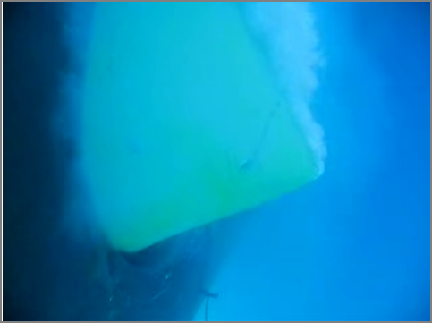
diving down into a bow thruster
This is a really awesome video that was liked to by gCaptain: Hull Inspection Video - More Exciting Than It Sounds
This is pretty wild see to the other side of things! I can't believe that they setup an air work environment in the thruster tube.
Dive in a bow thruster [youtube]
This is pretty wild see to the other side of things! I can't believe that they setup an air work environment in the thruster tube.
Dive in a bow thruster [youtube]
11.27.2007 14:39
USCG uses N-AIS to target a spill investigation
I have a paper that came out recently...
[PDF] Schwehr, K.D., McGillivary, P.A., Marine Ship Automatic Identification System (AIS) for Enhanced Coastal Security Capabilities: An Oil Spill Tracking Application, Oceans07 MTS/IEEE, Vancouver, B.C. 29 Sept - 4 Oct 2007.
Coast Guard to Test Oil from Seven Ships in Spill [marinelink.com]
[PDF] Schwehr, K.D., McGillivary, P.A., Marine Ship Automatic Identification System (AIS) for Enhanced Coastal Security Capabilities: An Oil Spill Tracking Application, Oceans07 MTS/IEEE, Vancouver, B.C. 29 Sept - 4 Oct 2007.
...
Several recent high profile cases have occurred where 'mystery' oil
spills were found near shipping channels, but no vessel could be
readily identified as their source. These incidents lead to extensive
and expensive efforts to attempt to identify the ships responsible. As
time passes in responding to these incidents, the likelihood of
confirming the identity of the ships diminishes. Unfortunately,
reports of vessels engaging in illegal oily waste discharge to reduce
fees for offloading the waste in port are ongoing. We here discuss use
of improved capabilities of near-continuous real-time position
location monitoring of shipping traffic using marine Automatic
Identification Systems (AIS) for ships that would facilitate
identification of ships responsible for illegal oily waste discharge.
...
And what do I see today?
Coast Guard to Test Oil from Seven Ships in Spill [marinelink.com]
Testing of oil samples taken from ships that might have spilled the
fuel that washed up in Atlantic Beach and Long Beach last week will
probably take place by next week, the Coast Guard said. After the
approximately 500 gallons of heavy No. 6 oil residue washed up on
almost a mile of beach, the Coast Guard used an automatic
identification system that reports a vessel's position by radio to an
agency office in Staten Island. The agency came up with nine vessels
that entered or left New York Harbor in the 48 hours before the spill
was detected by surfers. Coast Guard investigators from regional
offices in New York, New Haven, Conn., and Hampton Roads, Va.,
collected samples from the fuel tanks and cargo holds of the seven
ships identified by the New York vessel traffic center as headed to
U.S. ports. These will be compared at the Coast Guard Marine Safety
Lab in Groton, Conn., with samples collected from the beach by the
Marine Safety Detachment in Coram. If there's no match, the agency
will track down two other ships en route to overseas ports to obtain
oil samples. Twenty-four cubic yards of crude oil and contaminated
sand were removed from the beaches during the cleanup. The impact of
the spill on marine wildlife appeared to be negligible, officials
said. Source: Newsday
11.27.2007 08:24
Excuse me? I don't think I am who you think I am
Hmmm... I just don't get it. Why does python not know who I am?
BTW, this is with Mac OSX 10.4.11 intel and seems to be indepent of which version of python. But... if I open a new terminal, it all works
% ipython
In [1]: import os
In [2]: os.getlogin()
Out[2]: 'root'
In [3]: os.getuid()
Out[3]: 501
The bash shell seems to know:
& echo $USER
schwehr
& whoami
schwehr
And if I make a file, I am definitely not root:
% touch foo
% ls -l foo
-rw-r--r--   1 schwehr  schwehr  0 Nov 27 08:15 foo
Perhaps I should be doing os.getenv('USER') instead. That at least knows who I am.
BTW, this is with Mac OSX 10.4.11 intel and seems to be indepent of which version of python. But... if I open a new terminal, it all works
In [1]: import os
In [2]: os.getlogin()
Out[2]: 'schwehr'
Gotta love problems that are not reproducable.
11.26.2007 20:42
OpenArialMap
http://openaerialmap.hypercube.telascience.org/
This project is an attempt to gather data from various free and
open aerial imagery datasources around the world, and use them to
create a single, coherent open world view.
11.26.2007 09:34
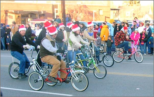
Dover Holiday Parade
The Dover Holiday Parade was a lot of fun this year. It even proves
that Dover has a biker gang. But, alas, no Kiss look-a-likes this
year. Sigh.
11.26.2007 09:05
Ordered a GPS
I am getting my self an i.Trek Z1 Solar Bluetooth Data Logger GPS from
here
[semsons.com]
11.26.2007 08:41
Peter Mitchell's Thesis Defense - 2D Flow Visualization
This is the second defense in two weeks for Colin's students. Today
is Peter Mitchell:
UNH COMPUTER SCIENCE - Master's Thesis Defense
THE PERCEPTUAL OPTIMIZATION OF 2D OCEAN CURRENT FLOW VISUALIZATIONS WITH SURFACE TEMPERATURE USING HUMAN-IN-THE-LOOP LOCAL HILL CLIMBING
THE PERCEPTUAL OPTIMIZATION OF 2D OCEAN CURRENT FLOW VISUALIZATIONS WITH SURFACE TEMPERATURE USING HUMAN-IN-THE-LOOP LOCAL HILL CLIMBING
Abstract: Flow visualization is the graphical representation of vector
fields or fluids that enables an observer to visually perceive the
forces or motions involved.  The fields being displayed are typically
dynamic and complex, with a vector direction and magnitude at every
point in the field, and often with additional underlying data that is
also of interest to the observer.  Distilling this mass of data into a
static, two-dimensional image that captures the essential patterns and
features in a way that is intuitively understandable can be a daunting
task.
.
Historically, there have been many different techniques and algorithms
to generate visualizations of a flow field.  These methods differ
widely in implementation, but conceptually they involve the
association of significant aspects of the data field (e.g., direction,
velocity, temperature, vorticity) to certain visual parameters used in
the graphic representation (e.g., size and orientation of lines or
arrows, foreground and background color, density/sparsity of graphical
elements).  For example, the velocity of a field could be mapped to
color, line width, line length, arrow head or glyph size, etc.  There
are many such potential parameter mappings within each technique, and
many value ranges that can be used to constrain each parameter within
a given mapping, resulting in a virtually limitless number of possible
permutations for visually representing a flow field.  So, how does one
optimize the output?  How can one determine which mappings and what
values within each mapping produce the best results?  Such
optimization requires the ability to rapidly generate quality
visualizations across a wide variety of parameter mappings and
settings.
.
We address this need by providing a highly-configurable interactive
software system that allows rapid, human-in-the-loop optimization of
two-dimensional flow visualization.  This software is then used in a
study to generate quality visual solutions to a two-dimensional ocean
current flow plus surface temperature over a variety of parameter
mappings.  The results of this study are used to identify relevant
rules and patterns regarding the efficacy of each combination of
parameters, and to draw some general conclusions concerning 2D flow
visualization parameter mapping and values.
.
Date: November 26, 2007
Time: 11:00 a.m.
Location:  Kingsbury N233
Committee:
Thesis Advisor: Colin Ware
R. Daniel Bergeron
Alejo Hausner
11.25.2007 10:53
NTP restart on Mac Laptop network change and Verizon VZAccessManager + Cisco VPN
In a sudden act of procrastination, I decided to fix my network time
(NTP) setup on my laptop. What a way to procrastinate, eh? Here is what
I did... First, the ntp config that comes with Mac OSX just sucks.
Also, looking at the system log, I now see that the newer version of the Verizon connection manager seems to be aware of the Cisco VPN client software that I use. I figured it was time another try of the VPN and this time it worked! From /var/log/system.log:
sudo mkdir /var/log/ntpstats
sudo emacs /etc/ntpd.conf
# This is the line that comes with the mac:
#server time.apple.com minpoll 12 maxpoll 17
#
# /etc/ntp.conf, configuration for ntpd
#
# ntpd will use syslog() if logfile is not defined
#logfile /var/log/ntpd
#
driftfile /var/run/ntp.drift
statsdir /var/log/ntpstats/
#
statistics loopstats peerstats clockstats
filegen loopstats file loopstats type day enable
filegen peerstats file peerstats type day enable
filegen clockstats file clockstats type day enable
#
# You do need to talk to abuncha NTP servers
server 0.us.pool.ntp.org
server 1.us.pool.ntp.org
server 2.us.pool.ntp.org
server 3.us.pool.ntp.org
server 0.north-america.pool.ntp.org minpoll 12 maxpoll 17
server 1.north-america.pool.ntp.org minpoll 12 maxpoll 17
server 2.north-america.pool.ntp.org minpoll 12 maxpoll 17
#
# ... and use the local system clock as a reference if all else fails
# NOTE: in a local network, set the local stratum of *one* stable server
# to 10; otherwise your clocks will drift apart if you lose connectivity.
server 127.127.1.0
fudge 127.127.1.0 stratum 13
# By default, exchange time with everybody, but don't allow configuration.
restrict default kod notrap nomodify nopeer noquery
# Local users may interrogate the ntp server more closely.
restrict 127.0.0.1 nomodify
You can then force a restart of ntp. I suggest watch in the system log in another window.
# Window 1
sudo tail -f /var/log/system.log
# Window 2
SystemStarter restart "Network Time"
Now for laptops, ntp is likely to get wedged every time the laptop leaves/returns to the internet. Following How to perform an action on change of network[macosxhists], I edited the kicker file for the network (this is 10.4.11):
sudo emacs -nw /System/Library/SystemConfiguration/Kicker.bundle/Contents/Resources/enable-networkAnd made this change:
# From
/System/Library/StartupItems/NetworkTime/NetworkTime start
# To
/System/Library/StartupItems/NetworkTime/NetworkTime restart
Now check on the ntp system: ntpq -p -n remote refid st t when poll reach delay offset jitter ============================================================================== 132.177.137.2 128.10.252.7 2 u 1383 256 340 95.592 0.104 402.440 82.165.184.7 74.208.4.166 3 u 1379 256 340 162.323 33.797 5.747 209.132.176.4 .CDMA. 1 u 1383 256 340 156.286 -3.097 0.384 208.100.3.151 128.105.201.11 2 u 1382 256 340 95.572 -6.588 40.938 69.36.240.252 69.36.224.15 2 u 1379 256 340 251.479 36.842 17.826 66.96.30.35 139.78.133.139 2 u 1635 68m 1 187.738 16.972 0.001 64.202.112.75 .CDMA. 1 u 1634 68m 1 104.038 -2.208 0.001 209.167.68.100 192.5.41.209 2 u 1633 68m 1 94.400 -0.719 0.001 *127.127.1.0 LOCAL(0) 13 l 17 64 377 0.000 0.000 0.001 Looks like the system is still figuring itself out...
Also, looking at the system log, I now see that the newer version of the Verizon connection manager seems to be aware of the Cisco VPN client software that I use. I figured it was time another try of the VPN and this time it worked! From /var/log/system.log:
Nov 25 10:24:00 CatBoxIII kernel[0]: CiscoVPN : interface: ppp0, filter attached.
Nov 25 10:24:00 CatBoxIII kernel[0]: CiscoVPN : current MTU for ppp0 is 1500, saving it.
...
Nov 25 10:25:35 CatBoxIII kernel[0]: CiscoVPN : shutting down VPN driver.
Nov 25 10:25:35 CatBoxIII kernel[0]: CiscoVPN : waking up VPN driver.
Nov 25 10:25:58 CatBoxIII configd[36]: posting notification com.apple.system.config.network_change
As a note to users of the VZAccess Manager software, the Verizon tech that I talked to this weekend said that the automatic software update checks for verizon pretty much do not work. You have to manually check every so often. I just went from 3.3 to 3.7 this weekend. I still get a fair number of kernel panics and wedged connections, but it does work a bit better. The download site: Supported Devices [vzam.net]
11.25.2007 09:52
The new wave of small form factor computers
There are a number of new and cool computers. They are still out of
the impulse purchase price range (and I don't have time for any more
toys), but they are still very cool. I love my apple laptop, but I
get really tired of carrying it all over the planet. I'm in a funny
state... I have never personally owned a GPS. How weird is that?
The Nokia N810 Portable Internet Tablet is about $450 and has a built in GPS. The best part is the size and weight... 128cc and .25 kg. But it is not worth the price. It does say that it has USB 2.0, so it might be an okay datalogger and if I knew that I could connect it to my Verizon EVDO usb modem and/or a full sized keyboard/mouse, I might be tempted.
n810 tech specs
The second interesting PC is the ASUS Eee PC. It is a fair bit bigger with a 7" display and has more storage space with a 4G solid state storage system for $400. But no GPS or camera at that price. It's quite a bit heftier at 4.4 lbs.
Could I go without my laptop for any period of time? I don't think I could do software development with either of these system. I think the N810 could be a reasonable device to just always have with me if it worked with my EVDO.
If I had more time to play, I would be getting a USB or Bluetooth USB device as they run $35-100, but alas, I just don't have the time. A GPS hand held navigation system (i.e. the kind that you can put in a car, but you can also take with out) would be handy for all my work trips, but I think I am about to drown in electronics and the associated cables.
The apple iPod touch with wifi looks cool too, but I think I'll wait until mission ops for that one. If only it was truely programmable (like python on board), had a GPS, and a USB for my EVDO card... Steve Jobs, are you listening? The ipod touch needs to be crossed with the N810.
11.25.2007 07:34
bar graphs in gnuplot 4.2
GNUplot 4.2 a big step over previous versions. Not to say that
previous versions were bad. Many of the graphs I made to get through
my thesis were done with gnuplot. But the new bar graph functionality
is very nice.
First the original graph style.
Now to make a bar for each data type:
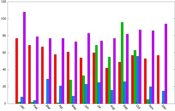
And finally, lets stack the data: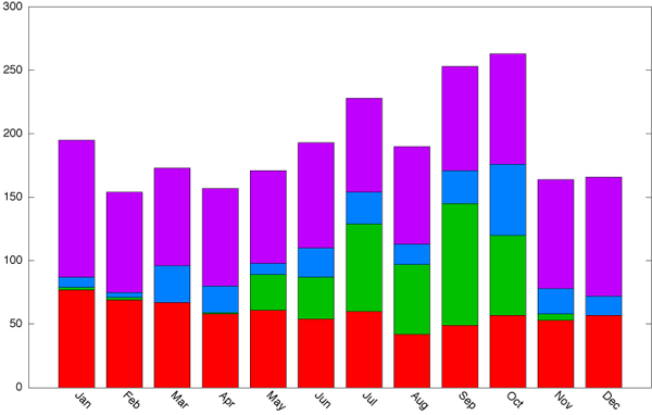
On a mac with fink, you can find more on histograms in:
First the original graph style.
set xtics nomirror rotate by -45
set style data linespoints
plot 'mydata.dat' using 2:xtic(1) t 2, \
'' u 3 t 3,\
'' u 4 t 4,\
'' u 5 t 5
Now to make a bar for each data type:
set style data histogram
set style histogram cluster gap 1
set style fill solid border -1
set boxwidth 0.9
replot
And finally, lets stack the data:
set style data histogram
set style histogram rowstacked
set style fill solid border -1
set boxwidth 0.75
replot
On a mac with fink, you can find more on histograms in:
/sw/share/doc/gnuplot/demo/histograms.dem
11.24.2007 14:01
M.S. Explorer having troubles in Antarctica"
No word that I can find on the state of the ship interms of oil
containment. Being in polar regions is serious business. Hats off
to the rescuers.
Antarctic Cruise Ship Picks Up 154 Shipwreck Survivors [VOA]
Antarctica Expedition Cruise
GaP Adventures - Explorer
The image from the G.A.P. web page:

These two images are from the Chilean Navy:
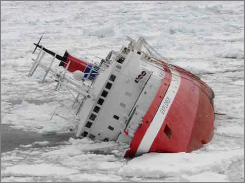
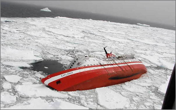
Antarctic Cruise Ship Picks Up 154 Shipwreck Survivors [VOA]
...
The Norwegian vessel, Nordnorge, picked up 154 people - all the
passengers and crew of the cruise ship M.S. Explorer, which hit an ice
floe before dawn on Friday and immediately began taking on water.
...
By Friday evening, several hours after the rescue operation was
complete, the stricken Explorer disappeared beneath the Antarctic
waves.
...
Less than a year ago, M.S. Nordnorge was involved in another Antarctic
rescue. The Norwegian cruise ship evacuated 294 passengers after
another ship from the same cruise company, M.S. Nordkapp, ran aground
on a remote Antarctic island. The Nordkapp was later refloated.
Not a good trend for this company. I think this is the advertisement for the cruise:
Antarctica Expedition Cruise
 The 10 day Classic Antarctica Expedition, run by G.A.P
Adventures, is the ultimate introduction to the great 'White
Continent' and includes many of the wildlife and scenic highlights of
the Antarctic Peninsula, Drake Passage and the South Shetland Islands,
home to some of the planet's most impressive wildlife and dramatic
landscapes.  Birds, including large penguin rookeries, rub shoulders
with seal colonies while orcas and whales are often seen plying the
icy waters. Throughout the voyage a team of lecturers and staff will
share their knowledge of the remarkable natural history of Antarctica,
along with entertaining stories from its earliest and most notable
expeditions.
GaP Adventures - Explorer
IAATO Approved:
In April of 2006 G.A.P Adventures became a full member in IAATO
(International Association of Antarctic Tour Operators). IAATO was
founded in 1991 to advocate, promote and practice safe and
environmentally responsible private-sector travel to the Antarctic and
now represents about 95% of all annual tourists to Antarctica. In 1996
IAATO developed an independent Onboard Observer program to ensure that
companies applying to become members meet their detailed and extensive
regulations for visiting Antarctica. This past Antarctic season G.A.P
Adventures carried one such observer onboard their M/S Explorer and
met IAATO standards. Subsequent to this, G.A.P Adventures was voted in
as full member to IAATO at their 17th annual meeting. IAATO developed
a set of Guidelines for tourists to Antarctic, which were subsequently
adopted by the Antarctic Treaty parties as part of their Environmental
Protocol. It is both GAP's and IAATO's hope that our passengers will
return home with a basic understanding of the continent and will be
ambassadors for the Great White Continent.
The image from the G.A.P. web page:
These two images are from the Chilean Navy:
11.24.2007 11:39
Compact bit representations of geometry?
I tried posting to the gdal mailing list, but I have to lookup the
correct new mailing address as the forwarding currently bounces. If
you have an opinion on this kind of thing, please email me at
kurt _at_ ccom.unh.edu or better yet, on my livejournal posting. I have to propose something to the standards
group soon and I want to have some feedback. I wonder about things
like non-concave polygons and triangle meshes. Too many things
running through my head.
What I am trying to send to the gdal mailing list:
I figured this is probably a good place to ask this question as you all work with a wide range of systems. I am looking to propose a couple a binary messages for maritime communication that must specify regions in a very limited message size. I'd like to be able to handle a range of different geometries using a couple different messages to obtain the most geometry being sent with the minimum amount of bandwidth. Something standard like WKB (OSgeo's Well-Known Binary) would be nice, but uses too much space. An example of the existing message to define a point is the lat/lon fields in this message:
ais_msg_3.html
structs-inc.xml
Where a point takes 55 bits.
I figure a circle is reasonable easy by just adding a radius. For a "rectangle", I'm wondering if a point with a dx and dy (in meters or 1/600000's of a degree) would be workable rather than two corners.
Then there comes the necessity of specifying an arbitrary polygon. I'm thinking that I have to bite the bullet and come up with a max number of points two fit within the bit constraint of the max message size that I am going to allow (368 bits).
Any thoughts? I'm trying to propose a standard that doesn't do more harm than good
11.24.2007 08:23
BlueForce satellites
From Jane's:
ViaSat plans US Army FBCB2-BFT satellite upgrade
ViaSat intends to increase the capacity of the US Army's Force XXI
Battle Command Brigade and Below - Blue Force Tracking (FBCB2-BFT)
satellite network by a factor of at least seven in its solution for
the planned system upgrade. In April 2007 ViaSat was awarded an
initial USD9.3 million contract by FBCB2-BFT prime contractor,
Northrop Grumman, to develop a prototype network and terminals for the
system that provides situational awareness for ground and air
platforms and which is seen as a key technology in US command and
control at the tactical level.
11.24.2007 08:15
What is successful blogging?
I keep seeing posts about strategies for successful blogging and I
realize that I am not a normal blogger. Beth Canter has interesting
articles on social communities and RSS
Subscriber loyalty, but that is just not me. Some of my friends
are blogging on systems like LiveJournal (LJ) and when they post, many
others (including me) comment on their posts. It is interesting to see
just how many responses they get. Quite amazing.
I don't allow comments (another than people emailing me) and I don't track how many people read my blog. I don't have any adds and I am not going to add any. Something like 95% of my posts are really only meant for me as research notes. I think I've scare off my family from the text long ago and they only occasionally look at my blog for the pictures. Here are a couple things that have happened to me in the last year that tell me that my blog is working for me:
I don't allow comments (another than people emailing me) and I don't track how many people read my blog. I don't have any adds and I am not going to add any. Something like 95% of my posts are really only meant for me as research notes. I think I've scare off my family from the text long ago and they only occasionally look at my blog for the pictures. Here are a couple things that have happened to me in the last year that tell me that my blog is working for me:
- I walked onto a job site last year and the first thing the team said was "We like how you are using python"
- Just last week I went to a conference and someone told me that my blog was the reason that they knew about the conference and were attending
- And the most important of all... every time I go back to my blog as a reference
11.23.2007 14:31
AIS wikipedia page updated
Unfortunetly, nobody else at eNavigation modified the Wikipedia
AIS page. I was catching up on some reading and ran into part of
my stack of documtation. Here is the update I just submitted. This
is definitely very incomplete.
- ITU-R M.131-2 Technical Characterisics for a Universal Shipborne Automatic Identification System using Time Division Multiple Access in the VHF Maritime Mobile Band. Version 3 is in the works.
- ITU-R M.493-11 Digital Selective Calling System for use in the Maritime Mobile Service
- [[NMEA 0183]]
- IEC 60936-5 - Guidelines for the use and display of AIS information on Radar
- IE 60945 Maritime Navigation and Radio-communication Equipment and Systems - General Requirements - Methods of Testing and Required Test Results
- IEC 62320 - Maritime navigation and radiocommunication equipment and systems - Automatic Identification Systems - Part 1: AIS Base Stations - Minimum operational and performance requirements - methods of test and required test results
- IALA Navguide Dec 2001 - Chapter 4 - Universal Automatic Identification System (AIS)
- IALA Guideline No. 1028 - The Automatic Identification (AIS) Vol. 1, Part I, Operational Issues
- IALA Guidelines on the Universal Automatic Identification System (AIS), Vol. 1, Part II, Technical Issues
- IMO SN/Circ.236 - Guidance on the Application of AIS Binary Messages - Defines the 7 international test binary messages
- The Maritime Domain Awareness Data Sharing Community of Interest (MDA DS COI) Pilot, Data Vocabulary and Schemas, Version 1.0, 16-June-2006
- United States Voluntary Observing Ship Project ([[http://www.vos.noaa.gov/ VOS]])
- [[Lrit]] Long Range Identification and Tracking
11.23.2007 10:37
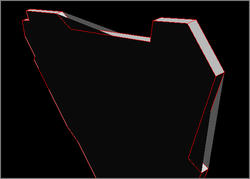
Lightwave VRML export to Inventor pieces
Today, I'm doing a little bit of work with VRML 2.0 that was exported
from LightWave. The conversion process does some strange things. After
my quick conversion of a piece of geometry, it looks pretty bad:
My conversion process to strip down the object removes the VRML 2.0 appearance marks and I have to insert Inventor 2.1 ShapeHints like this:
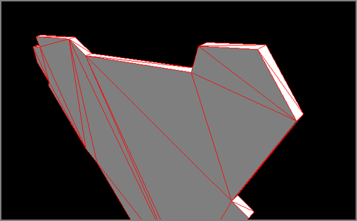
My conversion process to strip down the object removes the VRML 2.0 appearance marks and I have to insert Inventor 2.1 ShapeHints like this:
ShapeHints {
                  vertexOrdering CLOCKWISE
                  shapeType SOLID
		  faceType UNKNOWN_FACE_TYPE
	   }
The results are more like the geometry expected by the people who work
with Lightwave:
11.23.2007 09:33
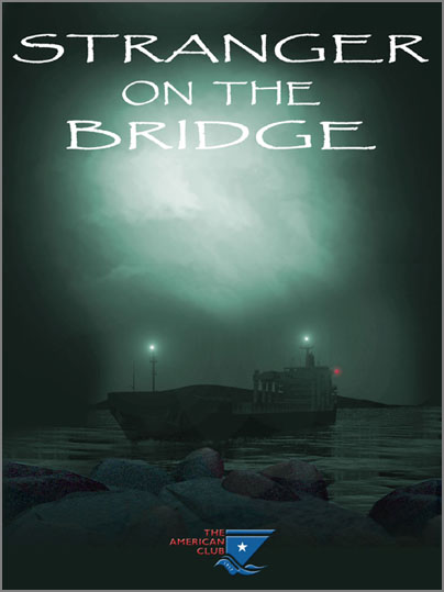
DVD on working with pilots - "Stranger on the Bridge"
The American Club has a new video titled Stranger
on the Bridge that talks to the deck crew of ships about working
with pilots.
11.22.2007 23:07
Healy Mapserver demo
This week, we had a demonstration of the mapserver system from the
Healy. The website that we saw is not open to the public, but they do
have other sites that are open to anyone. Really great stuff with a
lot of custom JavaScript. However they did say that they are planning
to go to OpenLayers.
http://mapserver.eol.ucar.edu
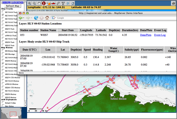
http://mapserver.eol.ucar.edu
Thu Nov 22 14:57:52 EST 2007
UK AIS network phase 3
MCA Rolls Out Phase 3 UK AIS [Hydro International - News]
The UK AIS network, which was developed by Kongsberg Norcontrol IT and
the MCA, went live in April 2006. All 18 MCA run Maritime Rescue
Co-ordination Centres (MRCC) are networked around the UK coast to
provide one integrated maritime domain awareness system...
...
hase three includes new functionality within the C-Scope User
Interface, including: BMT SARIS support - search and rescue graphical
display: VHF Direction Finding - triangulating position of a vessel
through radio transmission: Transmission and receipt of AIS Messages -
including safety text and control messages: Track reclassification -
mark specific vessels for easy identification and tracking: high
visibility warning object - no erroneous settings used for extended
periods.
11.22.2007 08:55
Argo ocean floats make slashdot
Floating Computers Keep an Eye on the Oceans, which links to silicon.com's article
The article is more frustrating than helpful. Sites that make you go through 7 pages for a small article so that they can get 50 million banner adds in front of me drive me nuts. But it is good to see programs like argos get noticed.
The article is more frustrating than helpful. Sites that make you go through 7 pages for a small article so that they can get 50 million banner adds in front of me drive me nuts. But it is good to see programs like argos get noticed.
The Met Office is taking part in a global programme to monitor the
world's oceans to improve understanding of how they influence climate
change.
.
The Argo programme uses thousands of floating devices like the one
pictured, which provide continuous data from even the remotest parts
of the world's oceans.
.
The Met Office manages the UK part of the programme and has deployed
around 230 Argo floats to date. It works in partnership with the
British Oceanographic Data centre, National Oceanography Centre in
Southampton and the UK Hydrographic Office.
Figure from UCSD:
11.21.2007 11:07
Different types of bridge fenders
Different bridge fender design might have averted bay oil spill [SFGate]
Bridge's design fends off severe damage from tanker [Professional Mariner]
This image is from the USCG assesment video. I need a better image for sure.
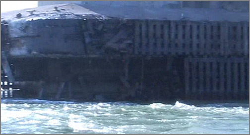
...
The accident in Portland's harbor caused no damage to the bridge or
the tanker, and unlike the Cosco Busan's crash into the Bay Bridge,
not a drop of oil was spilled.
.
The reason, transportation officials say, was a state-of-the-art
fender system designed to protect ships as well as the bridge.
.
"It was a pretty severe impact," said John Buxton, chief bridge
maintenance engineer for the Maine Department of Transportation. "But
(the fender system) worked perfectly."
...
Any one have a picture of the Portland bridge fender system that I can post?
Bridge's design fends off severe damage from tanker [Professional Mariner]
At 1645 on May 6, Hawk, a tanker transporting 11.3 million gallons of
No. 6 fuel oil from a refinery in the U.S. Virgin Islands, struck the
Casco Bay Bridge. The 31,709-grt tanker hit the bridge on its port
side between the No. 1 cargo tank and the forepeak. But a fender
system protecting the bridge pier absorbed the impact. There were no
injuries to the crew, no oil was spilled, and no damage was done to
the Greek vessel.
...
This image is from the USCG assesment video. I need a better image for sure.
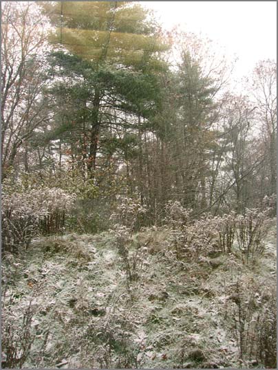
11.20.2007 17:00
First snow - picture
I didn't get a chance to get a real picture, so here is out my window.
There was at least an inch of snow on my car this evening. Pretty slushy
out there right now.
11.20.2007 13:50
Remko's notes on GMT in OSX 10.5
Remko posted some notes about GMT on Mac OSX 10.5 in the GMT mailing
list. I'm duplicating the notes here so that I don't loose them.
- Leopard has a new way of launching X11 (by itself) whenever you start an X
  application. But this requires some work to set up correctly if you have been
  fidgeting with X11 on Tiger.
  . Remove ~/.xinitrc. I had it so that X11 wouldn't automatically launch xterm.
    That won't happen anymore by default. It you want xterm, simply click the
    xterm icon in /usr/X11/bin or start xterm from the Terminal.app.
  . Remove X11 from your Login Items in the Accounts preference pane. Take if also
    out of the Dock so that you are not prone to start X11 from there. It doesn't work
    that way any longer.
  . Make sure NOT to set the DISPLAY environment variable. DO NOT put it in your
    .cshrc or .bashrc. X11 will not launch automatically when you do.
    MacOSX will set it to something like: tmp/launch-Uhmf6W/:0
    So type: echo $DISPLAY to check that's the case.
  . You may also want to say goodbye to .Xdefaults (at least font settings).
  . Now X11 should automatically launch when you type e.g. "gv" in a Terminal window.
  . By the way: also trash ~/.gv. The ghostscript setting -dGraphicsAlphaBits=4
    that I had in there made gv crash when is started plotting fonts.
- The preference file ~/Library/Preferences/org.x.X11_launcher.plist is created.
  When you just launch X11 applications from the Terminal, you can ignore it.
  But if you launch X11 manually by clicking the icon --which you shouldn't--
  it will launch xterm. It will also cause an additional launch of xterm when you
  click a file associated with an X11 application (see below).
  The xterm, I have learned, is just there to cause X11 to launch.
  You can avoid launching the xterm, but still have X11 be launched, type
  $ defaults write org.x.X11_launcher app_to_run /usr/X11/bin/xhost
  or edit the file mentioned above and change "xterm" to "xhost".
- The launcher is really nice. Without much ado you can now attach gv to launch
  when double clicking a .eps or .ps file. Much faster than launching Preview
  which will change your plot into an ugly PDF. Here are the steps:
  . Get XDroplets (http://www.rhythmiccanvas.com/software/xdroplets)
  . Unpack and ignore the "XDroplets Setup" !
  . Dig into XDroplets and move the X11-Others folder inside to your Applications
    folder. Inside are the goodies: ready to launch links to your favorite X11
    applications. Rename the folder if you want and trash stuff you don't need.
  . Go to any .eps file, select it, and click Cmd-I (Get info).
  . In the "Open with" portion, click the dropdown and select "Ghostview".
  . Click "Change All..." and "Continue".
  . Do the last three steps also for a .ps file.
  . Now every .eps and .ps file opens with ghostview.
- 3-Button emulation doesn't work (but 3-button mouse does). Fixed in available
  XDarwin release of Xquartz 1.2a3: http://www.x.org/wiki/XDarwin.
  You may need to activate 3-Button emulation again in the X11 Preferences.
- You couldn't drag X windows between Spaces. Fixed in Xquarts 1.2a7.
- If you want to feed X11 screens from a remote host back to your local host,
  make sure /etc/sshd_config on the remote host contains "X11Forwarding yes"
  and use ssh -X to log into the remote host.
11.20.2007 11:25
First real snow of the year
First real winter snow of the season. There were a few flakes the
other day, but it is now very white outside my office window! From
John Kelly:
URGENT - WINTER WEATHER MESSAGE
NATIONAL WEATHER SERVICE GRAY ME
1008 AM EST TUE NOV 20 2007
.
...FIRST TASTE OF WINTRY WEATHER FOR MOST OF NEW HAMPSHIRE AND
WESTERN MAINE...
.
.A FRONTAL SYSTEM WILL STALL TO OUR WEST TODAY AND LEAVE THE COLD
AIR IN PLACE. PRECIPITATION IS STARTING OUT AS SNOW AND THE
MOUNTAINS WILL PICK UP BETWEEN 2 AND 5 INCHES. THERE BE PROGRESSIVELY
LOWER ACCUMULATIONS FURTHER SOUTH WITH LESS THAN AN INCH AT THE
COAST. SNOW WILL MIX WITH SLEET AND FREEZING RAIN IN NEW HAMPSHIRE
AND SOUTHERN MAINE...TRENDING MORE TOWARD RAIN NEAR THE COAST.
.
...WINTER WEATHER ADVISORY IN EFFECT UNTIL 5 PM EST THIS
AFTERNOON...
.
THE NATIONAL WEATHER SERVICE IN GRAY HAS ISSUED A WINTER WEATHER
ADVISORY...WHICH IS IN EFFECT UNTIL 5 PM EST THIS AFTERNOON.
.
SNOW AMOUNTS WILL RANGE FROM 2 TO 4 INCHES IN NORTHERN NEW
HAMPSHIRE TO LESS THAN AN INCH NEAR THE COAST. THE SNOW WILL MIX
WITH SLEET AND FREEZING RAIN THIS AFTERNOON...AND TREND MORE
TOWARD RAIN NEAR THE COAST.
11.20.2007 11:12
Oil spill hearings and operations map
Oil spill hearing: Congress goes after Coast Guard [AP/ABCLocal]
NOAA's IncidentNews has a page on the M/V Cosco Busan
Here is an incident map from the USCG from 18-Nov.
Operational Overview Map [PDF]
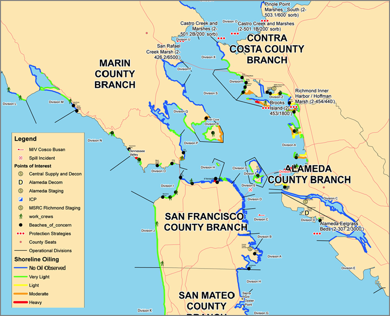
Cosco Busan Unified Command Oil Spill Response Website
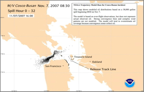
...
"Something on board that ship went terribly wrong," says Admiral Crain
Bone, U.S. Coast Guard.
.
Admiral Craig Bone is the Coast Guard's second in command, in charge
of vessel safety. He wouldn't directly blame the captain of the
container ship. However, his response pointed in that direction. As
for the clean up, he said it was handled as well as could be expected.
...
NOAA's IncidentNews has a page on the M/V Cosco Busan
Here is an incident map from the USCG from 18-Nov.
Operational Overview Map [PDF]
Cosco Busan Unified Command Oil Spill Response Website
11.20.2007 08:54
More SF spill related - Is AIS antiquated?
San francisco Oil Spill Hearings - A Response to Admiral Bone, USCG [gCaptain]
More on the hearings in SF: Hearing today at Presidio - tough queries for spill captain, pilot
And in terms of AIS, everyone keeps complaining about the Minimum Keyboard Display. I have to say that if all you have is an AIS with an MKD, you are not being a smart mariner. It doesn't cost much these days to buy a charting package that will do way better than the MKD's. The MKD is a seriously lame interface.
AIS makes its presence felt [Prefessional Mariner]
...
So the question becomes; "If AIS is a loved safety improvement
endorsed by maritime experts worldwide why does Captain Kelly (and
myself!) consider it antiquated?"
.
The reason is because we can do better! In the world of cutting edge
technology solutions are available now that would have given Cota and
VTS a much better chance of avoiding the incident. The problem, that I
suspect is an industry wide tendency, is two fold. First we are so far
behind the technology curve small improvements, like AIS, seem large
and exciting. Second, most licensed captains are Luddites (my self
included) who want to make sure a new system is reliable before
implementing it aboard ships.
.
I come to this conclusion because, despite my writings on the need to
improve shipboard technology, I initially had the same reaction as
Adm. Bone but quickly changed my mind. Why?  Because Capt. Kelly is
correct, our systems are antiquated and when new lifesaving
improvements become available we must break away from the statement
that has been rehearsed by ship captains for centuries; "Only history
will tell if this is a good idea". Exciting changes are happening
worldwide and improvements in communications (the number one failure
in all good incident chains) are leading the way. We must change with
the times and embrace technology as the benefit is a reduction of
incidents and a preservation of the environment and human life.
...
More on the hearings in SF: Hearing today at Presidio - tough queries for spill captain, pilot
And in terms of AIS, everyone keeps complaining about the Minimum Keyboard Display. I have to say that if all you have is an AIS with an MKD, you are not being a smart mariner. It doesn't cost much these days to buy a charting package that will do way better than the MKD's. The MKD is a seriously lame interface.
AIS makes its presence felt [Prefessional Mariner]
Another problem is that the display screen on the minimum keyboard
display (MKD) unit for AIS equipment is so small that it is not useful
for navigation, according to pilots and captains. The screen can be as
small as 4 inches wide by 2.5 inches tall.
11.20.2007 06:18
XML standards
This article rings true to me. I'm working to try to create several
different standards that use XML and when we tried to work with GML,
we really hit a wall. We are trying to avoid complexity such that our
work will get used. Only other thing is that namespaces have been
really painful for me. The seem to hurt more than they help. (Or I
need to better learn how to use them.)
Standardize the jellybeans not the jars
Standardize the jellybeans not the jars
...
A rule of thumb for many situations is that industry standard groups
(and, indeed, inhouse schema developers), may be well advised to
standardize data elements eagerly but container elements suspiciously:
standardize the jellybeans not the jars. The next bloke may likes your
jellybeans but have his own jars.
.
Various approaches to do this come to mind: think in terms of creating
a vocabulary rather than a language; split your industry standard in
two, with the tightly coupled elements in one normative section and
the loosely-coupled elements in another non-normative section, perhaps
with different namespaces even; use open content models and
order-independence for loosely-coupled elements.
...
11.19.2007 12:31
Stephen Schaeffer's defense today
Stephen is defending this afternoon:
UNH COMPUTER SCIENCE
Master's Thesis Defense
AUGMENTED HAPTIC INTERFACE FOR FLOW VISUALIZATION
by
Stephen Schaeffer
University of New Hampshire
Master's Thesis Defense
AUGMENTED HAPTIC INTERFACE FOR FLOW VISUALIZATION
by
Stephen Schaeffer
University of New Hampshire
Date: November 19, 2007
Time: 3:00 p.m.
Location:  Kingsbury N233
Abstract: A novel 3D computer interface is proposed in which a
physical handle containing force sensors and capable of simulating
virtual touch through force feedback is coupled to a variety of
virtual tools in a 3D virtual environment. The visual appearance of
each tool reflects its capabilities. At one moment a user might feel
they are holding a virtual grabber, activated by squeezing, and at
another moment they are holding a virtual turntable activated by
physical motion of a virtual wheel. In this way it is intended that
form and function can be combined so that users rapidly learn the
functional capabilities of the tools and retain this learning. It is
also intended that the tools be easy to use because of intuitive
mappings of forces to actions. A virtual environment is constructed to
test this concept, and an evaluation of the interface conducted.
.
Committee:
Advisor:  Dr. Colin Ware, CCOM
Dr. R. Daniel Bergeron, Computer Science
Dr. Jim Weiner, Computer Science
11.19.2007 12:09
Python and JavaScript debugging/development
Debugging Python by ynniv has some interesting notes about using
debuggers in python. I don't end up using the debugger much (or
really at all). I did play with python debugging in Eclipse and that
was pretty awesome. His work to trap exceptions in the debugger:
On the JavaScript front: putting rhino to work gives a tip on how to get a readline like interface for a javascript interpreter.
On the JavaScript front: putting rhino to work gives a tip on how to get a readline like interface for a javascript interpreter.
#!/bin/bash
dir=$(dirname $0)
export CLASSPATH=${CLASSPATH}${CLASSPATH:+:}${dir}/rhino/\*
echo using CLASSPATH=$(printenv CLASSPATH) > /dev/stderr
[ "$1" = "-f" ] || { RLWRAP="rlwrap -C js" ;}
exec $RLWRAP java ${JAVAOPTS} \
org.mozilla.javascript.tools.shell.Main -strict "$@"
11.19.2007 11:54
USCG SF radars - Cosco Busan
Coast Guard deflects blame in Bay Area spill [latimes]
SAN FRANCISCO -- The Coast Guard said Friday that its radar systems
could not have clearly shown that a cargo ship was about to collide
into the San Francisco-Oakland Bay Bridge and spill oil into the San
Francisco Bay.
...
John Meadows, a lawyer for the pilot, disputed McPherson's
characterization of the radar. "A properly functioning radar shows not
only the towers, but it will also show the piers and the buoys on
either side of the piers," Meadows said. "The VTS should have had
access to that. Any good, working radar would show these things."
...
Then there is some transcript of the VHF traffic:
...
"Roger, captain, are you still proceeding out?" Vessel Traffic Service
says at 8:29 a.m., according to a review of the audio.
.
"Traffic?" responds the pilot, acknowledging the communication.
.
"AIS shows you on 235 heading. What are your intentions? Over," VTS
asks. AIS is the Automatic Identification System, a shipboard tracking
system.
.
"Um, I'm coming around. I'm steering 280 right now," the pilot says,
indicating he was shifting the rudder as he made a turn.
.
"Roger, understand you're still intending the Delta-Echo span, over,"
VTS says, referring to the opening under the bridge between bridge
supports labeled Delta and Echo.
.
"Yeah, we're still Delta-Echo," says the pilot.
.
"Uh, roger captain," VTS says at 8:30.
.
At 8:32 the collision has occurred, and the pilot says: "Traffic, we
just touched the Delta span. I'm gonna go to trying to get our
anchor. Anchorage 9 ... Anchorage 7," the pilot says, suggesting some
confusion about where he was.
.
"Roger, unit Romeo at the Delta-Echo span, diverting to Anchorage 7,"
the Coast Guard acknowledges. Evidently the name Romeo was assigned to
the Cosco Busan.
...
11.19.2007 11:49
Cosco Busan - bridge/pilot interaction
Cosco Busan - Questions,Questions,Questions [gCaptain]
...
With an apparently malfunctioning radar and a lack of familiarity with
the primary method of navigation, did the pilot seek to confirm the
vessels position with the VTS and/or the accompanying tug?
.
VTS informed the pilot that the ship was off course, which the Pilot
disputed and shortly afterwards a lookout shouted a warning that there
was a bridge support ahead and the vessel went hard right and allided
with the Delta bridge support.
...
11.19.2007 11:46
Cosco Busan and location of the fuel tanks
Cosco Busan Crew Remain Silent During NTSB Interview [from gCaptain]
...
Built in 2001, the Cosco Busan is among the growing number of bigger,
faster container ships that have "winged tanks" - fuel tanks arrayed
along the sides of the ship.  The IMO convention, adopted in March
2006, requires that by 2010 all new ships with an oil fuel capacity of
600 cubic meters or more must have their fuel tanks deeper inside the
ship and behind two walls. That rule affects most large commercial
ships, and would have affected the Cosco Busan.  Bea said few are
aware of the action taken by the London-based IMO, even within the
shipping industry, because the licensing bodies that put those
regulations into effect have yet to write and distribute information
about it.
...
The above text is from the San Jose Mervury News, which in the 80's and 90's put out the best science section of a news paper that I have ever seen. But I haven't read that paper since the 90's so I can't comment on their current report.
11.19.2007 10:46
NOAA Update on SF spill response
NOAA,
Partners Remain Active in Spill Response Natural Resource Damage
Assessment Process Underway
Attachted to the article shows a view of the incident command facility.
...
The overall response operations, according to the U.S. Coast Guard,
include over 1,200 active participants from federal, state and local
agencies. The U.S. Coast Guard reports that approximately 80 different
vessels, including oil response vessels, skimmers, and support ships,
have been active since the spill.
.
NOAA's Integrated Ocean Observing System regional partner, the Central
and Northern California Ocean Observing System through the
state-funded Coastal Ocean Current Monitoring Program, has been
assisting in the spill tracking as well as using High Frequency Radar
systems both within San Francisco Bay and the Gulf of Farallones in an
effort to provide real-time information to the response teams.  The
derived currents are being sent directly to responders as well as
posted on the CeNCOOS Web pages. CeNCOOS continues to work with its
partners, providing environmental information as it is requested by
NOAA HAZMAT, NOAA National Marine Sanctuary Program, State of
California Department of Fish and Game, and California Office of Spill
Prevention and Response.
.
Clean-up progress includes beach areas of Alameda and Contra Costa
counties. Over-flights and assessment have determined that there
remains very little surface water oil product that is recoverable and
a total of 14,974 gallons of the oil have been recovered through
Nov. 14.
...
Attachted to the article shows a view of the incident command facility.

11.19.2007 10:38
NOAA Story - Endangered Right Whales Headed South for Winter
Endangered
Right Whales Headed South for Winter Alert for Mariners and Fishers in
Southeast U.S. Waters
Each year, pregnant females migrate southward more than 1,000 miles
from feeding areas off Canada and New England to the warm, calm,
coastal waters off South Carolina, Georgia and northeastern Florida to
give birth and nurse their young.  These waters are the only known
calving area for the species.
.
Collisions with ships and entanglement in fixed fishing gear are the
two greatest threats to the recovery of North Atlantic right whales,
which is why it is important that all mariners and fishers are aware
of the following regulations and recommendations:
    * Federal law prohibits approaching or remaining within 500 yards
       of right whales.
    * Gillnet fishing and possession is prohibited annually in the
      Southeast U.S. Restricted Area North, Nov. 15 - April 15, with
      an exemption for transiting through this area if gear is stowed
      in accordance with the rule.
    * Gillnet fishing is prohibited annually in the Southeast
      U.S. Restricted Area South, Dec. 1 - March 31, with limited
      exemptions for gillnet fishing for sharks and Spanish mackerel.
    * Recommended routes are in place for mariners entering or leaving
      the ports of Jacksonville and Fernandina, Fla., and Brunswick,
      Ga.  The routes are expected to reduce the chances of ship
      strikes with whales.
    * Speeds of 10 knots or less are recommended when consistent with
      safe navigation.
    * Always wear polarized sunglasses and stay alert in right whale
      habitat.  Although right whales are large animals, they have
      dark skin, no dorsal fin, and can remain at, or just below the
      water's surface making them extremely difficult to see.
...
11.19.2007 10:19
Maritec AIS news
Maritec has a news page with a whole bunch of interesting AIS
articles. I am biased because, right now, the first item is about my
upcoming AGU presentation.
Maritec News: Automatic Identifucation System, AIS, UAIS
My AGU poster: Google Earth Visualizations of the Marine Automatic Identification System (AIS): Monitoring Ship Traffic in National Marine Sanctuaries
Third SAR-Lupe satellite launched successfully into its orbit Automatic Identification System (AIS) for receiving ship signals also on board the COSMOS launcher for OHB
And there are a more on the Maritec news feed...
Maritec News: Automatic Identifucation System, AIS, UAIS
My AGU poster: Google Earth Visualizations of the Marine Automatic Identification System (AIS): Monitoring Ship Traffic in National Marine Sanctuaries
Third SAR-Lupe satellite launched successfully into its orbit Automatic Identification System (AIS) for receiving ship signals also on board the COSMOS launcher for OHB
The COSMOS-3M also carried an Automatic Identification System (AIS)
for ships on board. OHB and LuxSpace Sarl, a company owned by OHB
Technology AG, are working on the validation of this and following
systems. OHB is building seven new ORBCOMM satellites in which the AIS
will be implemented for the US Coast Guard for global monitoring of
shipping traffic.
I saw GateHouse at the conference last week, but I never got a chance to talk to them. I did get to spend some time talking to them at AIS06 last year.
COM DEV International and GateHouse A/S of Aalborg, Denmark, have
announced the signing of a strategic alliance agreement to work on
data management systems for COM DEV's space-based AIS (Automatic
Identification System), currently under development.
And there are a more on the Maritec news feed...
11.17.2007 13:24
Dover farmers market
Today, Dover had a farmers market over at the McIntosh cooking school. Very nice. The next one is Dec 22nd.
11.17.2007 13:22
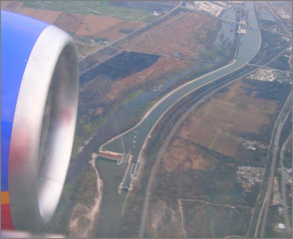
More images from plane flights
Update 2008-11: Frank Reed pointed me to Glory (optical phenomenon) [wikipedia]
Update: Barry Hunter pointed out that this first image is a Brocken Spectre (also Brocken spectre [Atmospheric Optics])
Here are two more images from recent plane flights that are interesting.
I think this is the same as a sun dog, but if someone knows the correct term for this rainbow halo around the shadown of the plane on the clouds, please let me know.

Here is an image of a lock on a river just to the west of Chicago Midway airport.
Update: Barry Hunter pointed out that this first image is a Brocken Spectre (also Brocken spectre [Atmospheric Optics])
Here are two more images from recent plane flights that are interesting.
I think this is the same as a sun dog, but if someone knows the correct term for this rainbow halo around the shadown of the plane on the clouds, please let me know.
Here is an image of a lock on a river just to the west of Chicago Midway airport.
11.17.2007 13:10
NASA MER rover driver interview
Interview:
The driver behind NASA's Mars Rovers Scott Maxwell must have one of
the best IT jobs in the solar system
We arrange for our work day here on Earth to match the Martian night,
so when the solar-powered Rovers shut down for the Martian night, they
send us pictures and other data showing us where they are now and what
they did the previous day. Then they go to sleep, and we go to work
planning the next Martian day of activities. At the end of our day, we
have a list of commands to send the Rovers when the sun comes back up
in the Martian sky. At that point, they go to work, and we go to
sleep.
11.16.2007 06:36
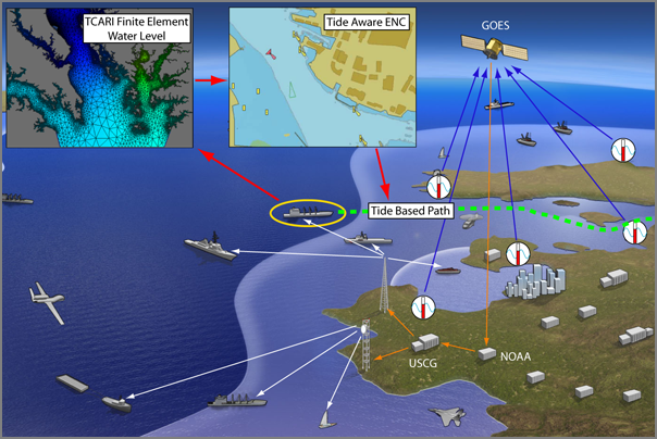
Water level via AIS
Yesterday I presented to the RTCM working group that is focused on AIS
binary messages for enhancing how Vessel Traffic Serverices work. I
talked about the application of binary messages for getting water level
and right whale notices to ships. As a part of that talk, I updated my
martime domain awareness (MDA) slide to be a bit more complete. The
background image that sets the location is from the USCG.
11.14.2007 07:08
RTCM/IMO AIS Test Report Document
I just ran into another interesting AIS document: "Guildlines on
Annual Testing of the Automatic Identification System (AIS)," IMO
MSC.1/Circ.1252 [RTCM PDF], 22-October-2007.
1. The Maritime Safety Committee, at its eighty-third session (3-12
October 2007), approved the Guidelines on annual testing of the
Automatic Identification System (AIS) developed by the Sub-Committee
on Flag State Implementation, as set out in the annex.
2. The purpose of an annual testing is to determine that AIS is
operational as defined in appropriate performance standards not
inferior to those adopted by the Organization*.
From the 3rd page:
- installation details including antenna layout, initial configuration report, interconnection diagrams, provision of the pilot plug and power supply arrangements;
- checking the correct programming of the ships static information;
- the ability of the AIS to receive ships dynamic information from the appropriate sensors;
- the ability to correctly input the ships voyage related data;
- a performance test of the equipment including radio frequency measurements; and
- an on-air test that the unit is working correctly using for example an appropriate Vessel Traffic Service (VTS) station or a suitable test equipment.
11.13.2007 10:51
LRIT - Long Range Identification and Tracking
Chris Shivery is talking about LRIT. Couple key points:
- Will transmit 4x per day for ships > 300 GT
- Data will be ID, Pos, and time of pos
- Cost is likely $0.25 per position for US
- The US government will pay for all transmission costs for US flagged ships
- The US will get all US flag vessel data plus everthing within 1000nm of US territory
- There is an option to poll ships at up to every 15 minutes for SAR (Search and Rescue)
- The US will pay to develop the international data center
- There will be a USCG Request For Information coming soon.
- Lights on is Dec. 2008
11.13.2007 09:27
Jorge Arroyo
Jorge has a whole mess of rule updates. So many that I had trouble
keeping up.
- Class B - The FCC should be publishing their cert process this month
- A new AIS reg should be out Monday. Should be published by OMB in December
- SAR AIS transponder coming. Should be much better than radar SAR transponders
- AIS Repeaters - Still working on the standard
- Still working on ECDIS AIS std
- NAIS Inc 1 is done rolling out
- A new standard for symbology will be out in January
- An LRIT rule has been published
11.13.2007 09:24
Conaughton - Administrator, Maritime Adminstration
We just had the keynote from Connaughton. One good quote:
"American officers are cheaper than other sources of officers"He talked about there being a world wide shortage are maritime officers of about 20,000 people.
11.13.2007 05:50
eNavigation 2007 starts this morning
eNavigation 2007 starts this morning. All of the morning's speakers are from the USCG. Here are the first talks:
- Moore - Introduction
- Jorge Arroyo - AIS regulatory Update
- Larson - SOLAS ECS Rulemaking
- Shivery - LRIT
- Ingalsbe - NAIS
- Tetreault - Vessel Traffic Management
- Moore - Q & A
11.12.2007 19:00
X3D and digital charting
I have been skeptical of X3D ever since I first heard about it. I
felt like VRML was a step backwards from the OpenInventor ASCII file
format. X3D has long suffered from poor support and from no one else
around me using it. I think now the tide is changing for me. Roland
was looking for a new file format for some of his work and he was
feeling some of the same frustrations I was having. Things like OBJ
just down have the flexibility to allow for us to do research with the
format. Inventing our own format has the drawback of working on our
own little island. Roland got really excited by X3D and really took
off with it. I've been holding back judgement to see how it worked
for him. Then came Matt into the mix. I now have two separate people
who keep showing me how great X3D is. There is still the issue of
complete support for the file format in 3D programs, but these guys
have shown me first hand that there is enough critical mass for this
format to win out. The final 1-2 punch was:
Matt has been doing some really awesome ground work that I have to show off a bit. Back in the day (aka before I got to CCOM), the VisLab created some great demos with billboard images in the Portsmouth Harbor. They took it one step further and tried a running mosaic along the water, but the results caused them to conclude that ribbon mosaics just are not the correct solution. However, Briana's masters thesis demonstrated that billboards do work. The alternative to billboards are CAD models of a harbor objects. When done right (aka by Chris and not by me), critical visual features can be really powerful. But there are two drawbacks two CAD models:
Here is a quick bit of code that Matt sent me from his initial explorations of X3D. The idea is to have either embedded JavaScript and/or Python handle the switching.
First his simple show an image file:

We are able to get all the images to show:
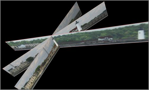
Once again, all this stuff was done by Matt P. Go Matt!
- doing some additional work in OpenInventor and getting frustrated with the format not being as uniform as XML
- Matt gave me a tour of X3D and showed me that it has all the benefits of XML and all the good things that I count on in OpenInventor
Matt has been doing some really awesome ground work that I have to show off a bit. Back in the day (aka before I got to CCOM), the VisLab created some great demos with billboard images in the Portsmouth Harbor. They took it one step further and tried a running mosaic along the water, but the results caused them to conclude that ribbon mosaics just are not the correct solution. However, Briana's masters thesis demonstrated that billboards do work. The alternative to billboards are CAD models of a harbor objects. When done right (aka by Chris and not by me), critical visual features can be really powerful. But there are two drawbacks two CAD models:
- They take a lot of time (and consequently $$$) to create.
- They miss many of the surrounding textural details that are not directly on the buildings.
Here is a quick bit of code that Matt sent me from his initial explorations of X3D. The idea is to have either embedded JavaScript and/or Python handle the switching.
First his simple show an image file:
<?xml version="1.0" encoding="UTF-8"?>
<!DOCTYPE X3D PUBLIC "ISO//Web3D//DTD X3D 3.1//EN" "http://www.web3d.org/specifications/x3d-3.1.dtd">
<X3D profile="Immersive" version="3.1"
  xmlns:xsd="http://www.w3.org/2001/XMLSchema-instance"
  xsd:noNamespaceSchemaLocation="http://www.web3d.org/specifications/x3d-3.1.xsd">
  <Scene>
    <Group>
      <Transform rotation="0 1 0 0" scale="149.35 1 19">
        <Shape>
          <IndexedFaceSet coordIndex="0 1 3 -1 2 3 1 -1">
            <Coordinate DEF="UnitSquare" point="-0.5 0 -0.5 -0.5 0 0.5 0.5 0 0.5 0.5 0 -0.5"/>
            <Normal vector="0 1 0 0 1 0 0 1 0 0 1 0"/>
            <TextureCoordinate point="0 1 0 0 1 0 1 1"/>
          </IndexedFaceSet>
          <Appearance>
            <ImageTexture url="FortConstitution_429.JPG"/>
          </Appearance>
        </Shape>
        <Shape>
          <Appearance>
            <LineProperties applied="true"
              containerField="lineProperties" linewidthScaleFactor="5"/>
          </Appearance>
          <IndexedLineSet colorPerVertex="false" coordIndex="0 1 2 3 0 -1">
            <Coordinate USE="UnitSquare"/>
            <Color color="0.9 0.7 0.6"/>
          </IndexedLineSet>
        </Shape>
      </Transform>
    </Group>
  </Scene>
</X3D>
Then Matt upped the ante to use a Proto. Based on what he
showed me here, it looks pretty good!
<?xml version="1.0" encoding="UTF-8"?>
<!--Warning:  transitional DOCTYPE in source .x3d file-->
<!DOCTYPE X3D PUBLIC "http://www.web3d.org/specifications/x3d-3.1.dtd" "file:///www.web3d.org/TaskGroups/x3d/translation/x3d-3.1.dtd">
<X3D profile="Immersive" version="3.1"
  xmlns:xsd="http://www.w3.org/2001/XMLSchema-instance" xsd:noNamespaceSchemaLocation="http://www.web3d.org/specifications/x3d-3.1.xsd">
  <Scene>
    <ProtoDeclare name="TextureScreen">
      <ProtoInterface>
        <field accessType="inputOutput" name="scale" type="SFVec3f" value="1 1 1"/>
        <field accessType="inputOutput" name="rotation"
          type="SFRotation" value="0 0 1 0"/>
        <field accessType="inputOutput" name="url" type="MFString"/>
        <field accessType="inputOutput" name="lineColor" type="MFColor" value="0.9 0.7 0.6"/>
      </ProtoInterface>
      <ProtoBody>
        <Transform>
          <IS>
            <connect nodeField="scale" protoField="scale"/>
            <connect nodeField="rotation" protoField="rotation"/>
          </IS>
          <Shape>
            <IndexedFaceSet coordIndex="0 1 3 -1 2 3 1 -1">
              <Coordinate DEF="UnitSquare" point="-0.5 0 -0.5 -0.5 0 0.5 0.5 0 0.5 0.5 0 -0.5"/>
              <Normal vector="0 1 0 0 1 0 0 1 0 0 1 0"/>
              <TextureCoordinate point="0 1 0 0 1 0 1 1"/>
            </IndexedFaceSet>
            <Appearance>
              <ImageTexture>
                <IS>
                  <connect nodeField="url" protoField="url"/>
                </IS>
              </ImageTexture>
            </Appearance>
          </Shape>
          <Shape>
            <Appearance>
              <LineProperties applied="true"
                containerField="lineProperties" linewidthScaleFactor="5"/>
            </Appearance>
            <IndexedLineSet colorPerVertex="false" coordIndex="0 1 2 3 0 -1">
              <Coordinate USE="UnitSquare"/>
              <Color color="0.9 0.7 0.6">
                <IS>
                  <connect nodeField="color" protoField="lineColor"/>
                </IS>
              </Color>
            </IndexedLineSet>
          </Shape>
        </Transform>
      </ProtoBody>
    </ProtoDeclare>
    <ProtoInstance containerField="children" name="TextureScreen">
      <fieldValue name="scale" value="149.35 1 19"/>
      <fieldValue name="rotation" value="0 0 1 -0.17453"/>
      <fieldValue name="url" value="FortConstitution_429.JPG"/>
      <fieldValue name="lineColor" value="1.0 0.3 0.3"/>
    </ProtoInstance>
    <ProtoInstance containerField="children" name="TextureScreen">
      <fieldValue name="scale" value="116.78 1 17"/>
      <fieldValue name="rotation" value="0 0 1 -0.8726646"/>
      <fieldValue name="url" value="FortConstitution_444.JPG"/>
    </ProtoInstance>
    <ProtoInstance containerField="children" name="TextureScreen">
      <fieldValue name="scale" value="107.45 1 18"/>
      <fieldValue name="rotation" value="0 0 1 -1.4835299"/>
      <fieldValue name="url" value="FortConstitution_446.JPG"/>
    </ProtoInstance>
  </Scene>
</X3D>
So, with a series of images like this:
We are able to get all the images to show:
Once again, all this stuff was done by Matt P. Go Matt!
11.12.2007 16:13
Google Earth - SF Oil Spill
Google Earth Blog has an article today of the SF Oil Spill: San Francisco Oil Spill in Google Earth. I haven't looked at the KML, but it appears that they are missing a timeline. Drat.
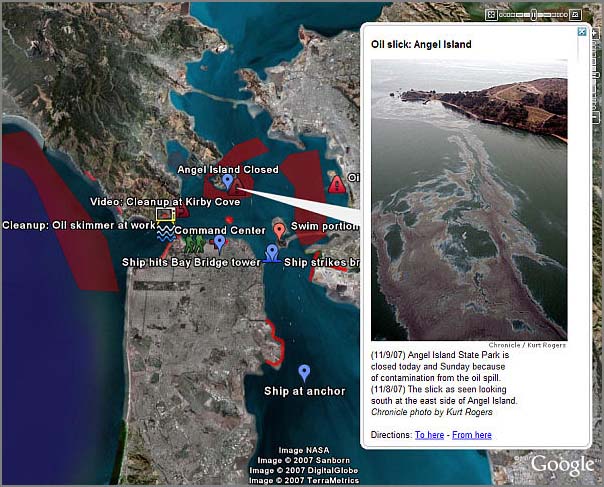
Image Source: Google Earth Blog
Image Source: Google Earth Blog
11.11.2007 19:06
Cosco Busan links
Here are a couple more links related to the Cosco Busan:
- Path of the Cosco Busan Hitting the Bay Bridge which I got from Follow the path of the Cosco Busan [gcaptain.com]
- Nautical Word of the Day - Allision [gcaptain.com]
- And an editorial about pilots that is quite scathing. Without know the facts, I have a hard time judging the comments in this. Pilot Loses His Bearings, San Fran a Nation Disaster [marine links editor's blog]
11.10.2007 16:00
eNavigation 2007 and wikipedia AIS page
Next week is the eNavigation 2007 conference in Seattle. This is an
opportunity for us as a community to work on the related Wikipedia
pages. In particular, the AIS
Wikipedia page needs work. I started a little bit today by adding
a link to the conference and editing the class A section just a bit.
You will see my changes under the username "goatbar." (That would be
from the Goats Bar in CO) I removed some overly vender specific stuff
and corrected some typos in the section on China's shore based system,
but that is only a start.
We desperately need a table with web links (or at least states the name) for each of the relevant specification documents. There are quite a few of these documents around. Please log into Wikipedia and make your changes. Let me know if you do make wikipedia changes and to what wikipedia pages and I will link to them.
We desperately need a table with web links (or at least states the name) for each of the relevant specification documents. There are quite a few of these documents around. Please log into Wikipedia and make your changes. Let me know if you do make wikipedia changes and to what wikipedia pages and I will link to them.
11.09.2007 14:52
Dirt simple javascript hello world
I'm trying to quickly get comfortable with JavaScript (errr... ECMA
script). I figured one way to be able to understand what is going on
is to play with the Mozilla command line JavaScript systems. There
are two ways to do this. The simplest is with spidermonkey. I'm on a
mac for this...
Now on to the 2nd method. This uses rhino, which is a JavaScript system writen in Java. (Taming the Rhino: Making Mozilla's Javascript Command Line a Little Less Brutish). Here is the hello-rhino.js. If someone can tell me how to doe this without hard coding the path to js.jar, please let me know.
Rob De Almeida chimed in with a 3rd method:
fink install spidermonkeyI now have a command line javascript interpreter available as /sw/bin/js. Time to try it.
% js
js> print ("Hello world")
Hello world
Then I hit Ctrl-D for an end-of-file character and I am back to the
command prompt. What if we want to execute JavaScript from a script
file? Not a problem. Here is my "helloworld.js" script.
#!/usr/bin/env js
print("Hello");
print(1+2);
Run it:
% chmod +x helloworld.js
% ./helloworld.js
Hello
3
Now on to the 2nd method. This uses rhino, which is a JavaScript system writen in Java. (Taming the Rhino: Making Mozilla's Javascript Command Line a Little Less Brutish). Here is the hello-rhino.js. If someone can tell me how to doe this without hard coding the path to js.jar, please let me know.
#!/usr/bin/env java -jar /sw/share/java/rhino/js.jar
print("Hello");
print (1+2);
Now running this:
fink install rhino
chmod +x hello-rhino.js
./hello-rhino.js
Hello
3
Rob De Almeida chimed in with a 3rd method:
   http://dealmeida.net/talks/3/shell.html
.
A Javascript shell written in Javascript (it's not mine, I copied from
somewhere else, and it has no dependencies, you can just copy it to your
machine). The advantage is that you can interact with the browser, eg:
.
   alert('foobar!');
11.09.2007 13:07
Spill update
Cosco Busan Unified Oil Spill Update [marinelink]
...
All crewmembers and the Pilot that were onboard the COSCO BUSAN at the
time of the accident were alcohol tested within the required two hour
time limit. The results of the tests were negative. All crewmembers
involved in the navigation of the COSCO BUSAN including the Pilot
provided samples to be drug tested within the first few hours. The
results for the drug samples will not be available until early next
week.
...
11.09.2007 08:48
NOAA press release of Costo Busan oil spill and photo
This is an image from the USCG of the M/V Cosco Busan after being damaged.
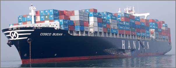
A closeup view of the damage:
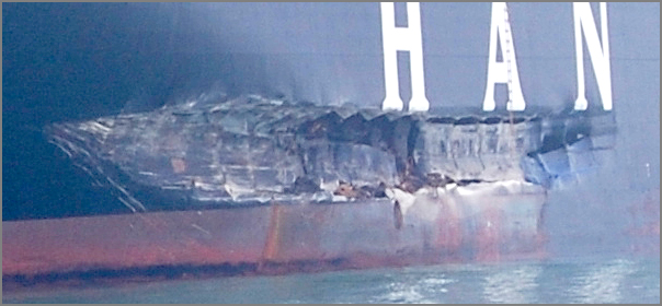
The full sized original image
NOAA Responds to San Francisco-Oakland Bay Bridge Oil Spill
For more images, you can do use this search on flickr:
http://flickr.com/search/?q=oil+spill&d=taken-20071106-20071109
A closeup view of the damage:
The full sized original image
NOAA Responds to San Francisco-Oakland Bay Bridge Oil Spill
NOAA organizations are on scene in San Francisco aiding in the
response to the estimated 58,000 gallons of intermediate fuel oil
spilled yesterday morning when the container ship M/V Cosco Busan
struck the Oakland Bay Bridge in San Francisco Bay.
.
While the incident occurred at the Bay Bridge, the spill is now
showing impact signs as far away as Muir Beach, which is outside and
north of the Golden Gate Bridge, as well as at Alcatraz and Angel
Islands. The Gulf of Farallones and Monterey Bay National Marine
Sanctuaries lie just outside the entrance to San Francisco Bay and are
areas of particular concern to marine resource managers.
...
For more images, you can do use this search on flickr:
http://flickr.com/search/?q=oil+spill&d=taken-20071106-20071109
11.08.2007 15:56
Cosco Busan oil spill
Just heard from my sister who said that the things are a mess.
According to sfgate, 58000 gallons of bunker fuel oil were spilled.
It is frustrating to have this happen to my hometown and be in a state
where I am not yet ready to help out with kind of event. It's hard
for to look at the pictures that are posted along with article.
Spill closes S.F. beaches; oil washes up on Marin Headlands
Spill closes S.F. beaches; oil washes up on Marin Headlands
...
Some officials say they expect the beach pollution to worsen early
this afternoon as the tide rushes out of the Golden Gate. Along Rodeo
Beach in the Marin Headlands, National Park Service ranger Robert Del
Secco kept visitors away from the beach, which is covered in dark
clumps of oil.
...
11.08.2007 10:10
geojson fink package
I cooked up a quick fink package for the geojson python library: GeoJSON at pypi.
geojson-py.info
Let me know if you use it and how it did. If I get feed back that it works, I will throw it in the fink unstable tree. And no, I have not made it to 10.5 yet. I'm still stuck back in the land of Mac OSX 10.4.
geojson-py.info
Let me know if you use it and how it did. If I get feed back that it works, I will throw it in the fink unstable tree. And no, I have not made it to 10.5 yet. I'm still stuck back in the land of Mac OSX 10.4.
11.08.2007 09:22
Possible NIH requirement for publishing in open journals
Slashdot had a very interesting article last night. Bill
to Require Open Access to Scientific Papers. This would
definitely shake things up in the academic world. Would other
research areas follow this too if the bill actually passes?
Congress is expected to vote this week on a bill requiring
investigators funded by the National Institutes of Health (NIH) to
publish research papers only in journals that are made freely
available within one year of publication.
11.08.2007 08:36
An allision seen through AIS
Here is a quick screen shot from Google Earth of the allision of the
COSCO BUSAN (MMSI=477968900) from yesterday. This should in no way be
considered or used as an official anything! It is very hard to tell
just from a ship track what happened. This first view is all the ship
traffic under the bridge for a 24 hour period including this incident.
SF is definitely a busy port.
Pulling out just this ship makes it a bit easier to see.
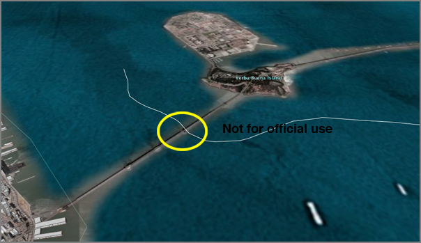
I hope there were no injuries and that any cleanup that was needed went smoothly.
Pulling out just this ship makes it a bit easier to see.
I hope there were no injuries and that any cleanup that was needed went smoothly.
11.08.2007 07:13
SF Bay Bridge allision
Ooops! Container Ship Collides with SF Bay Bridge [telstarlogistics]
This news item gave me a shock this morning! Somehow I made it through yesterday without hearing about this event. In USCG official MISLE speak, this was an "allision," not a collision. Hitting a stationary object or vessel is termed an allision, whereas two moving vessels coming into unintentional contact is a collision. (But as always, consult your language lawyer for the legal definition.)
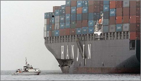
This news item gave me a shock this morning! Somehow I made it through yesterday without hearing about this event. In USCG official MISLE speak, this was an "allision," not a collision. Hitting a stationary object or vessel is termed an allision, whereas two moving vessels coming into unintentional contact is a collision. (But as always, consult your language lawyer for the legal definition.)
At 8:30 am this morning, the Cosco Busan, an 810-foot container ship,
collided with the base of one of the towers of the San
Francisco-Oakland Bay Bridge while the ship was under the control of a
Bar Pilot. The crash created a huge gash in the side of the ship and
triggered an oil leak that created an environmental mess in San
Francisco Bay. The San Francisco Chronicle carries the story:
11.07.2007 13:59
noaadata-py-0.30 released
In preparation for eNavigation, I've released version 0.30 of
noaadata-py. I have been looking at the proposed right whale notice
with a number of people and have updated it to take 2 slots. There is
currently space for 21 bits at the end that I have booked with
"Spare2." Notice that in timetoexpireN that a value of 0 now means
that a ring is not currently active (aka has no speed restriction).
That allows electronic chart systems (ECS) to display the monitored
zones that are currently clear without having to keep the regions in
their software distributions. Also, we have converted the buoy
(stationid) from an AIS string 6 to an 8-bit unsigned integer. This
gives the option for 256 buoys in each region.
whalenotice2.html
The changelog:
Additionally, I have finally released a draft fink info file for the mac people out there. This is not yet tested in any sort of way.
whalenotice2.html
The changelog:
- Pre eNavigation 2007 release
- xymt2kml now an optparse program that plays nicer
- svn propedit svn:keywords on all the scripts/*.py files for better tracking
- Added IMO messages 13 and 14 for RTCM meeting
- Reworking whalenotice message. Added a whalenotice2.xml that fully fills two slots
- Added basestation messages (msg 4) to the sqlite database
- Added gridding code in scripts: ais_pg*.py
- Added ais_traffic_analysis program
Additionally, I have finally released a draft fink info file for the mac people out there. This is not yet tested in any sort of way.
11.06.2007 10:42
San Diego fires nighttime pictures
My dad forwarded these pictures from the San Diego fire. They are
amazing. Source: unknown.
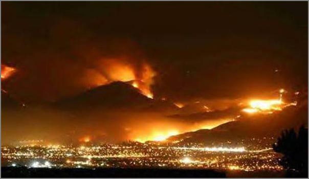
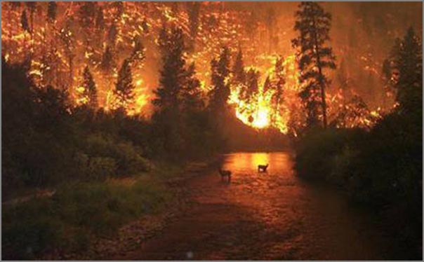
11.06.2007 09:56
Linux inside the Raymarine G-Series navigation system
From this article, More
3D & G, are they computers? [panbo], I was excited to see that the G
series is a Linux box.
From the Raymarine site:
From the Raymarine site:
The GPM400 G-Series Processor Module is the core of Raymarine's
premier navigation system. With a super fast processor, high
performance graphics hardware and a built-in high capacity hard drive
the GPM400 is up to 10 times faster than other embedded marine
navigation systems. The GPM400's rugged aluminum housing is shock
resistant and designed with heat dissipating fins for cool, quiet,
trouble-free operation under any conditions.
...
11.05.2007 07:52
VTS overview and pictures
VTS
- Working with large vessels by Capt Rodriguez
And gcaptain has a very nice series of VTS photos: VTS Photo Gallery - A look inside maritime vessel traffic services worldwide
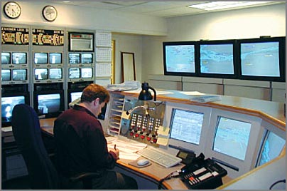
(Photo by Kam Chin)
...
VTS works much like the Air Traffic Control system, and has it's own
set of rules. The Navigation Rules state, "Such ships may discontinue
their watch on VHF channel 16 while in the VTS area." Think of VTS
(shipping lanes) as a highway with a median.  The Captains of
commercial vessels know the Rules, but aren't always sure of what to
expect from smaller boats. Vessels smaller than20 meters are required
to keep out of the way of a vessel in a VTS lane.
...
And gcaptain has a very nice series of VTS photos: VTS Photo Gallery - A look inside maritime vessel traffic services worldwide
(Photo by Kam Chin)
11.04.2007 14:57
Google Earth now has 3D buildings of UNH
Update: Colleen let me know that Aaron Mockrish created these 3D buildings.
These buildings may have been in Google Earth for a while, but I just noticed them. To whoever did these. Thanks!
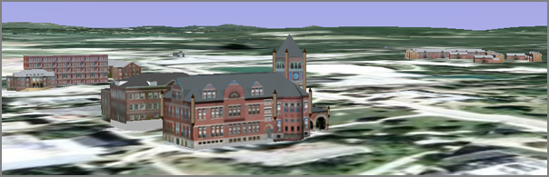
These buildings may have been in Google Earth for a while, but I just noticed them. To whoever did these. Thanks!
11.02.2007 10:42
Kernel panics with Mac OSX - Verizon
I have been experiencing many kernel panics and complete lockups
lately on my two Mac OSX laptops (one PPC/one Intel). These lockups
always seem to be associated with doing something with my Verizon USB
wireless modem. I've had three such events in two days. The nice thing
is that my Intel mac comes back up in about 30 seconds, but that should
not matter. Hopefully, upgrading to 10.5 will make some of this go away.
This feels much like when I tried to use Microsoft's Virtual PC. Suddenly
I had 10 kernel panics a day all with a nice MS Network driver notice.
I removed Virtual PC and have not had a kernel panic on the desktop in
a year despite heavy (even abusive) use.
My most recent lockup came from trying to add unh.edu to the search domains. I hit save and that was all she wrote.
I really do like having the Verizon mobile internet service, but it can be frustrating. Between that and spending all day next to a Verizon repeater that was cycling itself every 5-10 minutes yesterday, the service can be less than wonderful sometimes. It has worked for me pretty much everywhere I've been (accept in a moving vehicle) and has saved me lots of stress already. Now if we can just get Verizon to test their drivers a bit better and live up to that "unlimited" service that they advertise I would telling everyone to sign up for it.