08.31.2008 22:00
Moved old blog entries into nanoblogger
I just finished converting some of my
old blog posts from a raw weblog.html file into nanoblogger
entries. The eventual goal is to move beyond nanoblogger. I'm at
2780 entries and it is getting to be way to slow. I needed
something somewhat mindless to do today and that one won. The posts
range from July 2007 to Nov 2004. Somewhere I have a file with even
older stuff, but I can't seem to find it right now. I tried to do a
little bit of spelling and formatting cleanup. I even added a
couple images to the posts that referred to images.
08.30.2008 07:52
UNH Aquaculture Grant
Gregg announces funding for N.H. aquaculture initiative
DURHAM - U.S. Sen. Judd Gregg, R-N.H., announced that the University
of New Hampshire will receive $355,000 in federal funding for
aquaculture research efforts from the National Oceanic and Atmospheric
Administration (NOAA). These funds will allow UNH to research
technologies for reducing damage to offshore cages by marine organisms
and to develop new depth control technologies for optimizing fish
feeding, metabolism, stress reduction and growth.
...
"Technology for offshore aquaculture has advanced significantly in
recent years; however, we need to achieve greater efficiency for
production of native species like cod, haddock and halibut to be
commercially viable. Growth of marine organisms on cage surfaces
increases drag forces and reduces the flow of oxygen rich water to the
fish."
.
Langan continued, "This grant will develop advanced, non-toxic
materials that resist unwanted growth, greatly reducing the labor
required to keep cages clean. It will also develop precision depth
control of cages, so that fish can be placed depths where temperatures
are ideal for fish health and growth."
...
08.29.2008 12:31
Another seminar page - UNH Marine Program
There are too many sites out there
and none of them seem to have subscribable public calendars or RSS
feeds.
UNH Marine Program Seminars
UNH Marine Program Seminars
08.29.2008 08:19
New Nikon camera with GPS
Nikon's New D90 Shoots Video, Includes GPS, Steals Canon's 50D's
Thunder and the body is
$999 at Amazon.com
But... why not just put the GPS inside the camera? And how much will it cost?
Trackback: Nikon D90 SLR with GPS Support [slashgeo]
But... why not just put the GPS inside the camera? And how much will it cost?
GPS geo-tagging
The optional GP-1 GPS unit provides automatic real-time geo-tagging.
Trackback: Nikon D90 SLR with GPS Support [slashgeo]
08.29.2008 07:52
GeoDjango on This Week in Django podcast
Check out the podcast:
This Week in Django 32
GeoDjango is now in the Django svn trunk and the websites are merged: GeoDjango wiki [djangoproject.com]
There apparently is integration with OpenLayers and examples with GeoDjango. I have not had a chance to look at that as I am digging into the basics of plain Django plus the changes introduced as of 1.0 Beta 2.
For an intro to OpenLayers, see Take Control of Your Maps on A List Apart (ALA). Note that Briana S. was just encouraging me to check out ALA.
08.28.2008 14:07
More on ORBCOMM AIS
AIS
Satellite Announcement [gCaptain.com] via TheDigitalShip
ORBCOMM has successfully launched six AIS-equipped satellites (a Coast
Guard Concept Demonstration satellite and five Quick Launch
satellites) after the Cosmos 3M rocket carrying the company's payload
blasted off at 10:36am Moscow time (06:36 GMT) from Kapustin Yar, in
the Astrakhan Region, on June 19.  The satellites are equipped with
Automatic Identification System (AIS) technology to receive and report
transmissions from AIS-equipped maritime vessels from anywhere within
the satellite coverage area, information which is expected to be of
major interest to authorities interested in Long Range Identification
and Tracking (LRIT) in the marine domain.
...
Also, they annouce a new book by Andy Norris:
Digital Ship's resident navigation expert Andy Norris has launched a
new book, detailing some of the latest advancements in navigation
technology.  'Radar and AIS' by Dr Norris builds on the basic radar
theory and target tracking knowledge that seagoing officers already
have - while looking ahead into the future where New Technology (NT)
radars are hoped to provide significantly enhanced performance.
From the 1st July 2008, all new radars required mandatory AIS
(automatic identification system) integration. While much effort has
gone into ensuring that AIS, radar and chart information is
consistent, with uniform symbols and a standard resolution, operators
still need guidance and instruction.
...
08.28.2008 13:54
CCOM Weather Station
We've been pulling out the stops with
the new building. Andy M. setup a weather station on the
roof.

08.28.2008 12:36
Accessing the Apple Addresbook application
This is a pretty cool hint. I've
altered there example with a cut so you can't see actual people in
my address book.
% sqlite3 ~/Library/Application\ Support/AddressBook/AddressBook-v22.abcddb \
  "select ZADDRESSNORMALIZED from ZABCDEMAILADDRESS;" | \
  cut -d@ -f 2| sort -u | tail
sdsc.edu
sim.no
stanfordalumni.org
tone.jpl.nasa.gov
ucsd.edu
unh.edu
usgs.gov
yahoo.com
Quickly extract all email addresses from Address Book [macosxhints]
08.28.2008 09:18
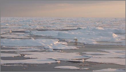
North Pole NOAA cameras
This is definitely a time where the
camera system needs to have an integrated GPS. I just sent StarDot
a suggestion to add EXIF fields to the images. Hopefully this will
come in future firmware additions. What is the path that this
camera has drifted? Where is it now?
Arctic theme page - Live from the the North Pole
noaa cam 2 latest
In this image, I did a little cropping to just pick out the part that is not just flat gray.
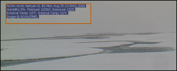
Arctic theme page - Live from the the North Pole
noaa cam 2 latest
In this image, I did a little cropping to just pick out the part that is not just flat gray.
% EXIF.py noaa2.jpg
noaa2.jpg:
No EXIF information found
08.28.2008 09:03
Sunrise in Scituate
From the NOAA dock last week as Matt
and I got ready for a cruise.

08.27.2008 21:23
Super basic CSS
I'm finally taking the time to
understand CSS more than just randomly hacking on things I only
guess are the right things to do (which usually works). Today, I
got Eric Meyer's CSS, The Definitive Guide, 3rd Ed. The web is one
great big distraction, so a physical book is often a relief. I
already feel more comfortable playing with CSS. Here is my first
pathetic test file:

Looking at the html that code2html output, I realize that I need to get a better code highlighter in my tool box.
<html>
<head>
<title>First CSS attempt</title>
<style type="text/css">
h1 {color: purple;}
body {background: orange;}
</style>
</head>
<body>
<h1>h1 heading</h1>
<p>General text</p>
<p style="color:red;">Second paragraph</p>
</body>
</html>
The results are not that exciting, but it does work:Looking at the html that code2html output, I realize that I need to get a better code highlighter in my tool box.
08.27.2008 19:55
Django 1.0 party in Mountain View, CA
Arg! I'm on the wrong coast right
now. I grew up not to far from the Tied House and ended up there
many times after long days coding just down the street at NASA Ames
in the Intelligent Mechanisms (Now the Autonomy and Robotics Area
or some such). Some very good memories there.
To celebrate the release of Django 1.0, we'll be holding a dinner
party at the Tied House in Mountain View on Saturday, September 6th at
7pm. The date and time are designed to tie in with DjangoCon, but
anyone is invited - especially those who can't attend DjangoCon.
.
We've reserved the whole restaurant for Django friends and
fans. Dinner starts at 7pm, and the festivities should continue until
about 10:30 or so. The party's free, though the dinner and drinks
aren't. Tied House has good food and great beer; come hungry!
.
To make the night extra fun, we'll be holding "lightning talks" at the
party - five minute presentations on various Django-related
topics. We'll be asking speakers at the conference to present vastly
twimmed-down versions of their conference talks, and we'll be opening
the floor up to anyone to present their own cool shit.
08.27.2008 13:35
django 1.0 beta2 differences
BackwardsIncompatibleChanges
There have been enough changes in Django since Practical Django Projects was released that it makes the book a bit challenging to use. For starters, the admin interface has been refactored. Gone from models.py are the prepopulated_from, core, edit_inline, min_num_in_admin, and num_extra_on_change keyword arguments. Also, adding class Admin: pass does not put your class into the admin interface. Now you have to do:
There have been enough changes in Django since Practical Django Projects was released that it makes the book a bit challenging to use. For starters, the admin interface has been refactored. Gone from models.py are the prepopulated_from, core, edit_inline, min_num_in_admin, and num_extra_on_change keyword arguments. Also, adding class Admin: pass does not put your class into the admin interface. Now you have to do:
class Category:
    # ...
from django.contrib import admin
admin.site.register(Category)
Also, the urls.py for admin has changed:
from django.contrib import admin
admin.autodiscover()
# ...
urlpatterns += patterns('',
    (r'^admin/doc/', include('django.contrib.admindocs.urls')),
    (r'^admin/(.*)', admin.site.root),
)
08.27.2008 11:46
JavaScript speedup with TraceMonkey
Steve L. just pointed me to this.
Sounds like the Firefox 3.1 release will be a huge deal.
<"http://www.eweek.com/c/a/Application-Development/Mozilla-Speeds-Up-JavaScript-with-TraceMonkey/?kc=EWKNLITA08262008STR1">Mozilla Speeds Up JavaScript with TraceMonkey
This week I'm seriously digging into Django for a web application. I'm sure I will need to do more than just add TinyMCE with JavaScript, so this is important. Steve has been doing some really exciting JavaScript work that will benefit from a better JS engine in Firefox.
BTW, I just made a package of Django 1.0 RC2 (Beta 2) that includes the geodjango/gis functionality. I can't believe geodjango is in the trunk! geodjango-20080827
I've just listened for the first time to the this week in django podcasts ( 33 to be exact ). The pod cast definitely was a good one for giving me more of a feel of some of the corners of Django that I have not gotten to yet.
<"http://www.eweek.com/c/a/Application-Development/Mozilla-Speeds-Up-JavaScript-with-TraceMonkey/?kc=EWKNLITA08262008STR1">Mozilla Speeds Up JavaScript with TraceMonkey
Mozilla has revved up its SpiderMonkey JavaScript engine with a new
just-in-time compiler. The TraceMonkey project boosts JavaScript
performance by an order of magnitude. TraceMonkey is slated for
release in Firefox 3.1 and is expected to also boost Canvas
development.
.
The folks at Mozilla have souped up JavaScript with a new just-in-time
compilation scheme in a project known as TraceMonkey, which boosts
JavaScript performance as much as 22.5 times depending on which
benchmarks and tests you use.
...
This week I'm seriously digging into Django for a web application. I'm sure I will need to do more than just add TinyMCE with JavaScript, so this is important. Steve has been doing some really exciting JavaScript work that will benefit from a better JS engine in Firefox.
BTW, I just made a package of Django 1.0 RC2 (Beta 2) that includes the geodjango/gis functionality. I can't believe geodjango is in the trunk! geodjango-20080827
I've just listened for the first time to the this week in django podcasts ( 33 to be exact ). The pod cast definitely was a good one for giving me more of a feel of some of the corners of Django that I have not gotten to yet.
08.27.2008 08:54
new noaa weather web site
New From NOAA - Southeast U.S. Marine Weather Website
[gCaptian.com]. How does this relate to nowCOAST?
National Weather Service, Southeastern U.S. Marine Weather
National Weather Service, Southeastern U.S. Marine Weather
08.27.2008 08:52
Arctic Healy links
Maintaining a presence in the Arctic requires a national
commitment [An Unofficial Coast Guard Blog]
CGBlog Find #9: USCG Healy - Arctic Mapping 2008 that points to USCGC Healy - Arctic Mapping 2008 (Baker)
Healy cruise plan - Page 4 has a list of science crew. It also shows that they are using a SEABEAM 2112 Bottom Mapping Echosounder and a Knudsen 320B/R Echosounder for mapping.
CGBlog Find #9: USCG Healy - Arctic Mapping 2008 that points to USCGC Healy - Arctic Mapping 2008 (Baker)
Healy cruise plan - Page 4 has a list of science crew. It also shows that they are using a SEABEAM 2112 Bottom Mapping Echosounder and a Knudsen 320B/R Echosounder for mapping.
08.26.2008 14:54
10 knots limit on the US East Coast
Warning... this is one giant posting.
I've extracted some key pieces of the FEIS NOAA submission... it's
a lot of text. There is no direct reference to what we are working
on with AIS or ListenForWhales.org.
NOAA Files Final Environmental Impact Statement on Ship Strike Reduction Measures Agency Seeks to Slow Ships to Protect North Atlantic Right Whales.
NOAA Files Final Environmental Impact Statement on Ship Strike Reduction Measures Agency Seeks to Slow Ships to Protect North Atlantic Right Whales.
NOAA's Fischeries Service is seeking comment on the final
environmental impact statement (EIS) for the Ship Strike Reduction
Rule. The EIS is one of the final steps in the process to implement a
final rule. The ship strike reduction rule aims to reduce the number
of endangered North Atlantic right whales injured or killed by
collisions with large ships.
.
The final EIS contains six alternatives, including NOAA's preferred
alternative that would require a vessel speed restriction of 10 knots
or less in designated areas along the U.S. East Coast. The preferred
alternative also includes a five year sunset provision to allow for
further consideration of ongoing scientific research.
.
"NOAA is looking forward to taking a significant step in our efforts
to protect right whales," said retired Navy Vice Admiral Conrad
C. Lautenbacher, Jr., under secretary of commerce for oceans and
atmosphere and NOAA administrator. "Our scientific analysis shows that
a 10-knot speed limit in critical areas will significantly reduce the
threat to these endangered marine mammals."
.
The 10-knot speed limit would apply to right whale feeding grounds
along the coast in the northeastern United States and to calving
grounds near the southeastern United States, where the whales spend
most of their time. In the mid-Atlantic area where right whales
migrate, the 10-knot speed restrictions would extend out to 20
nautical miles around the major ports. NOAA's Fisheries Service
researchers report that approximately 83 percent of right whale
sightings in the mid-Atlantic were within 20 nautical miles of
shore. The preferred alternative also would establish temporary
voluntary speed limits in other areas when an aggregation of three or
more right whales is confirmed.
.
With about 300 in existence, North Atlantic right whales are among the
most endangered whales in the world. Slow moving right whales are
highly vulnerable to ship collisions, since their migration route
crosses major East Coast shipping lanes. Along with existing measures
to prevent entanglement of right whales in fishing gear, this would be
the most comprehensive approach that NOAA has taken to regulate vessel
operators in its effort to help right whales recover.
.
"The bottom line is that this critically endangered species needs our
help," said Lautenbacher. "The preferred alternative is a balanced
approach grounded in science that would significantly enhance our
ability to protect right whales, but it would also take into account
concerns about the safety of ship crews and the impact on an important
segment of our economy."
.
The final EIS on the right whale ship strike reduction rule is a step
in the process to promulgate a final rule. The rule is part of NOAA's
broader ship-strike reduction efforts. Existing protective actions,
such as aircraft surveys and mandatory ship reporting systems that
provide advisories and information on right whale locations to
mariners, will continue. Additional steps include voluntary routing
measures, consulting under the Endangered Species Act with federal
agencies on operations of their ships, and an extensive mariner
outreach and education program.
.
NOAA's Fisheries Service is soliciting comments on the final EIS until
Sept. 29. After the close of the comment period, NOAA will consider
comments it receives and promulgate a final rule expeditiously. The
final rule will have an effective date 60 days following publication
in the Federal Register.
.
NOAA understands and predicts changes in the Earth's environment, from
the depths of the ocean to the surface of the sun, and conserves and
manages our coastal and marine resources.
Final Environmental Impact Statement [pdf]
...
Specific measures of each type are described in greater detail by
region of application in Sections 2.1.1 through 2.1.4. For each
measure, which alternative(s) include(s) it is specified. Only a
subset of the measures is included in the proposed action (Alternative
6), as summarized in Section 2.2.6.  As the modifications to the
Boston Traffic Separation Scheme (TSS) and creation of an Area To Be
Avoided (ATBA) in the Great South Channel are independent of the NMFS
rulemaking and the vessel operational measures considered in the FEIS,
they are no longer included as potential measures (see Section 1.4).
.
In all regions, unless otherwise noted, the vessel operational
measures would apply only to nonsovereign2 vessels subject to the
jurisdiction of the United States that are 65 ft (19.8 m) or greater
in length overall. Sixty-five feet is a vessel-size class recognized
by the maritime community and commonly used in maritime regulations
(e.g., Automatic Identification System [AIS]; International
Navigational Rules Act, Rules of the Road sections) to distinguish
between a motorboat and a larger vessel. All Federal vessels and those
state enforcement vessels engaged in enforcement or human safety
missions would be exempt. In response to comments about vessel
maneuverability, NMFS also decided to exempt all vessels from the
speed restrictions where oceanographic, hydrographic, and/or
meteorological conditions severely restrict vessel maneuverability
(see Section 1.4).
.
With regard to speed restrictions, NMFS' proposed limit is 10 knots;
however, for comparison purposes, the FEIS also considers speed limits
of 12 and 14 knots. Records of ship strikes in which vessel speed was
known indicate that the majority of serious injuries to, or deaths of,
whales resulting from ship strikes involved ships operating at speeds
of 14 knots or more (Laist et al., 2001; Jensen and Silber, 2003);
therefore, a vessel traveling at less than 14 knots would reduce the
likelihood and the severity of a ship strike. Recent analysis of these
same records indicates that the probability of death or serious injury
increases with ship speed. There is a 50 percent (0.26-0.71 for 95
percent confidence interval [CI]) chance that death or serious injury
will occur if a right whale is hit by a vessel traveling at 10.5
knots. The probability increases to 75 percent at 14 knots, and
exceeds 90 percent at 17 knots (Pace and Silber, 2005). Vanderlaan and
Taggart (2007) came to a similar conclusion, determining that the
probability of death from a collision was approximately 35-40 percent
at 10 knots, 45-60 percent at 12 knots, and 60-80 percent at 14 knots;
above 15 knots, it asymptotically approaches 100 percent.
.
Additionally, vessels traveling at lower speeds may also produce
weaker hydrodynamic forces.  At higher speeds, such forces have the
capacity to first push a whale away from a moving ship and then draw
the whale back toward the ship or propeller, resulting in a strike
(Knowlton et al., 1998). These forces increase with the vessel's
speed; therefore, a whale's ability to avoid a ship in close quarters
may be reduced at higher vessel speeds. In a modeling study using data
from observed encounters of right whales with vessels, Kite-Powell et
al. (2007) determined that more than half of the right whales located
in or swimming into the path of an oncoming ship traveling at 15 knots
or more are likely to be struck even if the whales attempt evasive
action.
...
Then at page 404
EL Paso - Southern LNG - Elba Island, Georgia
This LNG terminal on Elba Island, Georgia is already an existing
terminal (see Section 4.7.3.1 for a description of current operations
at this terminal); however El Paso - Southern LNG submitted a proposal
to FERC to expand this terminal. Southern LNG has agreed to notify LNG
terminals via an automated identification system (AIS) to slow to 10
knots or less when consistent with safe navigation. The AIS is
currently operational and sends an AIS message to all incoming
vessels. Current AIS data is being archived until a live feed to
NOAA's Southeast Regional Office AIS network is achieved. Informal
Section 7 consultation has been completed on this terminal and NOAA
has concluded that the project would not likely to adversely affect
Right Whales.
.
Offshore LNG Deepwater Ports
The two offshore facilities addressed in detail in this section that
would have potential impacts on right whales are the Neptune and
Northeast Gateway Deepwater Ports. Neptune has been approved and
construction started in July 2008, and Northeast Gateway is fully
operational. This section addresses the cumulative impacts of
constructing/operating these facilities and the increase in vessel
traffic generated by the proposed LNG terminals on right whales in the
reasonably foreseeable future.
.
Neptune LNG
The Neptune LNG terminal is being built approximately 22 mi (35 km)
northeast of Boston, Massachusetts, in a water depth of approximately
260 ft (79 m). One unloading buoy system at the deepwater port would
moor up to two shuttle regasification vessels (SRVs). There would be
an initial increase in vessel traffic in Massachusetts Bay during the
construction of the terminal and installation of a 10.9-mi (17.5-km)
pipeline that would connect to the existing Algonquin HubLine natural
gas pipeline (Neptune LNG, LLC, 2005). The Deepwater Port license
application includes estimates of the vessel traffic from operations
(including construction); support vessels are estimated to take 61
round trips per year, SRVs would take approximately 50 round trips per
year, and pilot vessels would also take 50 round trips per year,
accompanying the SRVs (Neptune LNG, LLC, 2005). Therefore, this
facility would increase vessel traffic by approximately 161 round
trips (322 one-way trips) per year.
.
The USCG and MARAD published a notice of availability for the FEIS on
November 2, 2006 (71 FR 64606), and the record of decision (ROD) has
been approved with conditions. In their scoping comments on the NOI to
prepare an EIS for the Neptune LNG Deepwater Port, NOAA specifically
requested that the EIS consider the potential impacts of the
construction and operation of the terminal on endangered species,
including right whales. While the FEIS does consider the potential
impacts of this vessel traffic and construction on right whales, the
findings of the BO supercede the conclusions in the FEIS.
.
In addition to the FEIS, these agencies consulted with NMFS under
Section 7 of the ESA. The BO resulting from this consultation
determined that the action may adversely affect but is not likely to
jeopardize right whales or adversely modify or destroy critical
habitat. During this process, the applicant and the agencies agreed to
the following mitigation measures (which are not specific terms and
conditions of the BO): seasonal speed restrictions of 10 knots or
less, in accordance with the proposed rule to reduce ship strikes to
right whales; year round speed restrictions in the Off Race Point SMA;
and installation of passive acoustic detection buoys (to determine the
presence of calling whales) in the portion of the Boston TSS that
passes through SBNMS. Right whale detections through the buoys or
reports from the Sighting Advisory System will be monitored prior to
entering the area, and appropriate action will be taken in response to
active sightings. Also, Neptune vessels will enter the Boston TSS as
soon as practicable and remain in the TSS until the Boston Harbor
Precautionary Area (see Figure 4-11).
.
Northeast Gateway
The Northeast Gateway LNG terminal is located offshore in
Massachusetts Bay, approximately 13 mi (21 km) south-southeast of the
city of Gloucester, Massachusetts, in Federal waters approximately 270
to 290 ft (82 to 88 m) in depth. The natural gas is delivered to shore
by a new 16.4-mi (26.4-km) pipeline from the deepwater port to the
existing Algonquin HubLine pipeline (Northeast Gateway Energy Bridge,
LLC, 2005). As with the Neptune project, the construction and
operation of this terminal will increase vessel traffic over current
levels. The Deepwater Port license application states that there would
be an estimated 55 to 62 Energy Bridge regasification vessels (EBRV)
arrivals per year. In addition, support vessels would take one trip
per week, or 52 trips per year. Therefore, this facility would
increase vessel traffic by 162 to 176 round trips (324 to 352 one-way
trips) per year (Northeast Gateway Energy Bridge, LLC, 2005).
.
The USGC and MARAD published a notice of availability for the FEIS on
October 26, 2006 (71 FR 62657), and the ROD has been approved with
conditions. In addition to commenting on the NOI, NOAA also provided
comments to assist the USCG with their completeness determination and
recommended the collection of additional data for further analyses
that will be necessary to evaluate the impacts on NOAA's trust
resources. These comments include NOAA's concern that the Northeast
Gateway project would negatively impact conservation within SBNMS,
specifically with respect to NOAA's plans to reconfigure the Boston
TSS to reduce the risks of collisions between ships and endangered
whales. NOAA issued an Incidental Harrassment Authorization (IHA) on
May 14, 2007 (72 FR 27077), which contained various monitoring and
mitigation measures to prevent ship strikes to right whales.
.
Northeast Gateway did include some mitigation measures in its
application. The applicant expressly states that "EBRV speed while
transiting outer Massachusetts Bay will be less than the sea speed of
the vessel because the vessel will be slowing down in preparation for
docking at the Northeast Port. In addition, Northeast Gateway will
observe seasonal speed restrictions while transiting through or in the
TSS adjacent to the Great South Channel and Off Race Point to minimize
potential ship strikes on whales" (Northeast Gateway Energy Bridge,
LLC, 2005).  NOAA's comment letter reiterated that while speed may
reduce the number of strikes, speed reduction alone will not reduce
the risk of ship strike to zero, and the additional vessel traffic is
expected to increase the risk of ship strike mortalities in SBNMS.
.
Another topic addressed with respect to right whales is the planned
construction period of late summer to early spring, which overlaps
with the high-use period of right whales in the area, primarily from
January through April. The actual construction period has since been
changed to May through November to avoid this seasonal
aggregation. Construction commenced in May 2007 and was completed in
November 2007. Also, noise during construction and the potential for
entanglement by fishing gear displaced by LNG sites pose additional
threats to right whales.  These topics have been analyzed in the EIS
and Section 7 consultations.
.
The BO for Northeast Gateway also came to a finding that the project
may adversely affect, but is not likely to jeopardize right whales or
adversely modify or destroy critical habitat. Through the Section 7
consultation process, the applicant and agencies voluntarily committed
to the following mitigation measures: a seasonal 10-knot speed
restriction in the Off Race Point and Great South Channel SMAs; a
year-round 12-knot speed restriction in the Boston TSS; and these
vessels will enter the TSS as soon as practicable, and remain in the
TSS until they need to divert to transit north to the deepwater port.
...
And in the comment section:
59b) Maybe AIS would be a means to track whales; it would be hard to do for
every whale, but it might be useful to help the ships identify where
the whales were.
Response:
If it were possible to develop this technology, it is likely many
years away. Experience with satellite tagging indicates that
attachment to the whale is the most significant challenge. More over,
even if it were possible to determine where every right whale was at
all times, the mariner would still need to take evasive action, e.g.,
limit speed.
Another comment:
72c) Commenter suggested a system with 24/7 real time reporting 365 days of
the year, where information would be transmitted back to a
clearinghouse, and then distributed to the maritime community through
AIS and radio, and then the mariners could make decisions for
themselves as to what avoidance actions they should take.
Response:
Currently the infrastructure for such a system does not
exist, and knowledge of right whale locations is only
part of the equation. A mariner must still take some type
of evasive action, which would be subjective. See the
final rule for a more detailed explanation.
And another:
94g) Commenter believes that implementing new technology, such as pop-up
buoys and tagging whales with transmitters, can improve the detection
of whales. Also, AIS with VHF radio communication and MSR should be
considered for real time ship strike avoidance.
Response:
See response to # 58d in reference to pop-up buoys
and #88a in reference to tagging whales.
Here are 58d and 88a... to go with the response above:
58d) Response: Pop-up buoy identification of whales has several
limitations; the whales must be vocalizing, the system
would not detect all whales present, and it is not always
possible to determine the number of whales without
visual verification. This approach would still require
evasive action by the mariner.
And finally:
88a) Strongly supports the 10-knot speed restriction. Support
Alternative 5, but if Alternative 6 is implemented, commenter
encourages NMFS to consider using telemetry devices to track
individual whales whenever possible. This would allow vessels to be
notified well in advance of the presence of right whales, and would
greatly improve the effectiveness of DMAs.
.
Response:
Support Acknowledged. Using telemetry devices would require attaching
a transmitter to all right whales to track each individual's
movement. Historically, tags attached to large whales have had a short
lifetime, and sometimes resulted in infection. Finally, while
telemetry may remain a useful tool for monitoring the movements of
individual animals, it is improbable for an entire population. Even
with knowledge of the location of every individual, the mariner would
still need to take evasive action, e.g. slow the vessel. This
increases unpredictability for shipping companies - an undesirable
outcome, as indicated by the industry. Known times and
locations of restrictions provide predictability.
08.26.2008 14:03
A blog from the Healy
Stephen Howard's Arctic web log
I woke up this morning to find out that the night watch saw a polar
bear at about 5am. Trying to hide my jealousy, I spent the next two
hours up on the bridge scanning for bears, but no luck. We have hit an
area of thick ice, with many floes four to six feet thick at the water
line and remnants of pressure ridges that are thrust above the ice
another eight feet or so. This is a good environment for bears, and
everyone is keeping their cameras handy in the event one happens to be
spotted. I've heard that last year at this same time fourteen bears
were spotted, and at about halfway through our cruise we've only seen
one. I did see a few fresh tracks of bears, though. Well, it's
something!
.
Because of the polar bear sighting, I thought I'd dedicate today's
journal entry to describing a few of the key marine mammal species in
this region of the Arctic. I'm no expert on this topic, but I've
located some books to help me out. I've also asked George, the
community observer from Barrow who I profiled earlier, to check it
over for me, as he has a great knowledge of these animals. Thanks,
George!
.
The top predator around here is, of course, the polar bear. These guys
can get enormous, up to 1800 pounds, and their principal prey are
ringed seals, which they sniff out and excavate from their birthing
lairs or stalk near the seal's breathing holes in the ice. Polar bears
are powerful swimmers, and can swim 60 miles or more in open water. On
open ice, they can run as fast as 30 mph! George says that in Barrow
it is not uncommon to see three or four bears foraging on the
beaches. When science teams deploy on the ice, Coast Guard crew go
down with guns in case a polar bear is around. The Inupiats have an
agreement with the federal government allowing subsistence hunting of
polar bears, which they use for food and fur. Other than that, there
is no commercial hunting of polar bears. There is much concern about
the future of polar bears; with thinning ice due to climate change,
there will be less seal pupping sites and therefore less for the polar
bears to eat.
...
08.26.2008 11:02
Alvin's replacement in the works
Thanks to Janice for pointing this
out:
New Sphere in Exploring the Abyss [nytimes]

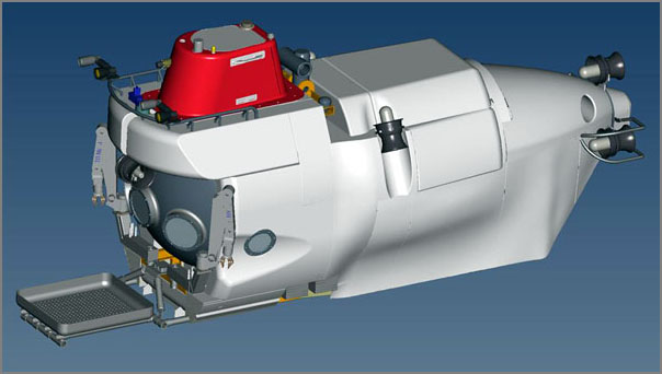
...
Alvin can transport a pilot and two scientists down 2.8 miles,
providing access to 62 percent of the dark seabed. The new vehicle is
expected to descend more than four miles, opening 99 percent of the
ocean floor to inquiry. But the greater depth means that the vehicle's
personnel sphere and its many other systems will face added tons of
crushing pressure.
...
Replacement HOV [whoi.edu]
08.25.2008 20:11
Submitted GeoEndNote to Thomson Reuters
Trackback: Sean Gillies points out
that similar mapping of locations for pubs has been done before:
Friends don't let friends use Endnote
I just submitted GeoEndNote as a suggested output format to Thomson Reuters' EndNote output style suggestion page.
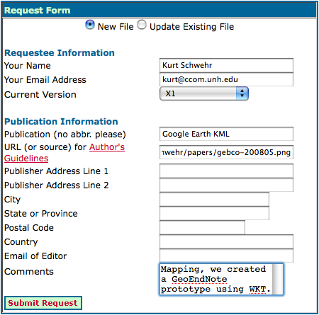
It would be cool if other tools like zotero (Firefox extension for references), OpenOffice, or JabRef pick up the same concept.
Also, just ran into BibTeXML. Was just thinking that XML would be more friendly than the straight bibtex format.
For an overview of many reference mangement programs, check out wikipedia: Comparison of reference management software. Note that KML, WKT, Google, spatial, location, or PostGIS do NOT show up in the document.
Kurt, I have in fact seen mapping integrated with Zotero. Shekhar
Krishnan used the GeoNames database to locate items by their place of
publication in a demo at THATCamp.
I just submitted GeoEndNote as a suggested output format to Thomson Reuters' EndNote output style suggestion page.
It would be cool if other tools like zotero (Firefox extension for references), OpenOffice, or JabRef pick up the same concept.
Also, just ran into BibTeXML. Was just thinking that XML would be more friendly than the straight bibtex format.
For an overview of many reference mangement programs, check out wikipedia: Comparison of reference management software. Note that KML, WKT, Google, spatial, location, or PostGIS do NOT show up in the document.
08.25.2008 16:36
Healy science team spots a polar bear
Just in the last two days, the
science team on the Healy spotted a polar bear.
I haven't seen any bears in the hourly aloftcon camera images, but we can always hope to see one. The ice ponds are a spectacular color.
20080825-2001:
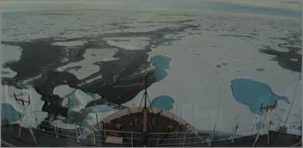
I haven't seen any bears in the hourly aloftcon camera images, but we can always hope to see one. The ice ponds are a spectacular color.
20080825-2001:
08.25.2008 11:14
Marine Measurement Forum
This is across the pond, so I will
not be going, but sounds interesting.
The Marine Measurement Forum (MMF) is a non-profit making, one-day
event that provides opportunities for the informal exchange of ideas,
knowledge, techniques and developments across an extensive range of
marine scientific measurement activities. Attendees typically include
scientists, surveyors, engineers, and business people from a variety
of organisations including research centres, academia, manufacturers,
survey companies, consultants, monitoring authorities, dredging
companies, port authorities, oil companies, etc. The MMF is normally
hosted within southern England with occasional excursions to other
parts of the UK.
.
Format: The event covers a single day and is organised such that the
average attendee can travel to and from the venue on the same
day. Frequency is targeted at 6 monthly intervals.
08.25.2008 11:07
noaadata 0.40 released
This version has two months of
changes. I've been slowly smoking out some bugs in the postgis
network bridge. Also, the regular expression (regex) for AIS NMEA
strings is a big help. noaadata
downloads
- aitutils/uscg.py - added a REGEX for AIS NMEA messages
- ais_positions.py works again - Bug report by Joe Healy
- aisutils.uscg - added a regular expression for the USCG format. Now need to move code to using this
- Fixed AIS NMEA encoding bug report by Miguel Eduardo Gil Biraud
- Added scripts/jpegexif2kml.py for geo tagged photos
- ais-net-to-postgis - better exception logging,
- ais-dumpnames - uses the uscg regex now to parse the nmea lines
- ais_pg_transitlines_noMakeLine - removed bug on vessels with no points
- ais_positions - lots of changes, but still not flexible
- six_min_avg.m - Matlab code by Val for tide stations
- ais_pg_transitsummary - timezone management with pytz. Now not specific to 2006
- tideconvert - for the memme station for June 2008 summer hydro class
- ais_pg_vesselsummary - new program to write excel spreadsheets
- database.py - fixed name handling bug with empty ship names. Traceback on trouble
- template.py - more examples
- binary.py - minor cleanup
08.25.2008 10:33
NOAA Natural Hazards db in kml
Links: Burning Man, Earth API, GlobalMapper, Hazards Database,
X-Prize [Google Earth Blog]
Historical Natural Hazards Database [Google Earth Community]
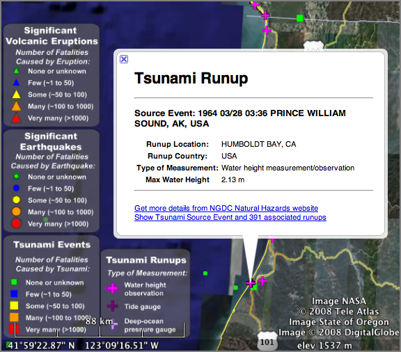
...
Natural Hazards Database - The NOAA National Geophysical Data Center
(NGDC) maintains a database of information about historical natural
hazards such as earthquakes, tsunamis, and volcanic eruptions. They
have created a KML file [Google Earth required.] which lets you view
the data which helps with planning for future events in areas like
disaster recovery, disaster response, etc. But, it also helps you get
a perspective on dangerous locations. This one is definitely worth a
look.
...
This database would have been helpful to have during my PhD!
Historical Natural Hazards Database [Google Earth Community]
08.24.2008 19:59
3DUI conference
IEEE
Symposium on 3D User Interfaces 2009, March 14-15, Lafayette,
LA. Papers are due in August. In conjunction with IEEE Virtual
Reality 2009
The IEEE Symposium on 3D User Interfaces 2009 is the fourth
international symposium focused on the topic of 3D UIs and will be
held to provide an intensive exchange between industrial and academic
researchers working in various 3DUI research areas and to trigger
discussions among participants. It builds on successful 3DUI workshops
in 2004 and 2005, as well as the IEEE 3DUI Symposiums in 2006, 2007
and 2008. The symposium will last for two days, and will be followed
immediately by the IEEE VR conference. The theme of the Symposium will
cover all areas of 3D UI research. The Symposium themes include, but
are not limited to, the following topics:
    * 3D input devices
    * 3D display devices
    * 3D interaction techniques
    * 3D user interface metaphors
    * 3D UIs for games
    * 3D UIs for CAD
    * Applications of 3D UI techniques
    * Biologically inspired 3D UIs
    * Collaborative 3D interaction
    * Desktop 3D UIs
    * Evaluation methods for 3D UIs
08.24.2008 13:24
Bill Borucki - Finding planets
William "Bill" Borucki was my first
boss at NASA back in 1989. He was very generous with his time and
got me started on my long and windy history working with NASA. I
did several projects with him. The first was on the
Acquire program to collect photometric data from robotic
telescopes. I later worked on software to try to find extrasolar
planets. [wikipedia] I never found any (PlanetSearch1991),
but now people have found many.


Systems engingeering for the Kepler Mission : a search for terrestrial planets (2006) Duren, Riley M., ... Borucki, Bill, ..., SPIE Astronomical Telescopes and Instrumentiation 2004.
Systems engingeering for the Kepler Mission : a search for terrestrial planets (2006) Duren, Riley M., ... Borucki, Bill, ..., SPIE Astronomical Telescopes and Instrumentiation 2004.
The Kepler mission will launch in 2007 and determine the distribution
of earth-size planets (0.5 to 10 earth masses) in the habitable zones
(HZs) of solar-like stars. The mission will monitor > 100,000 dwarf
stars simultaneously for at least 4 years. Precision differential
photometry will be used to detect the periodic signals of transiting
planets. Kepler will also support asteroseismology by measuring the
pressure-mode (p-mode) oscillations of selected stars. Key mission
elements include a spacecraft bus and 0.95 meter, wide-field,
CCD-based photometer injected into an earth-trailing heliocentric
orbit by a 3-stage Delta II launch vehicle as well as a distributed
Ground Segment and Follow-up Observing Program. The project is
currently preparing for Preliminary Design Review (October 2004) and
is proceeding with detailed design and procurement of long-lead
components. In order to meet the unprecedented photometric precision
requirement and to ensure a statistically significant result, the
Kepler mission involves technical challenges in the areas of
photometric noise and systematic error reduction, stability, and
false-positive rejection. Programmatic and logistical challenges
include the collaborative design, modeling, integration, test, and
operation of a geographically and functionally distributed project. A
very rigorous systems engineering program has evolved to address these
challenges. This paper provides an overview of the Kepler systems
engineering program, including some examples of our processes and
techniques in areas such as requirements synthesis, validation &
verification, system robustness design, and end-to-end performance
modeling.
08.24.2008 10:30
Camera with GPS to Google Earth track and thumbnails
I got my first draft of a GoogleEarth
map of the GPS camera run through Boston Harbor.
boston-gpscamera.kmz
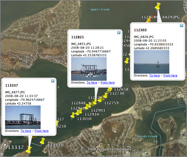
The source code will be out in the next release of noaadata as a script called "jpegexif2kml."
boston-gpscamera.kmz
The source code will be out in the next release of noaadata as a script called "jpegexif2kml."
08.23.2008 22:49
pyexiv2 - reading GPS info in JPG headers
I've been working on how to manage
the large number of georeferenced images that Matt and I collected
earlier this week. I'd like to be able to work directly in python.
I first tried EXIF.py. It works,
but it is not a proper python package.
% ./EXIF.py IMG_6829.JPG  | grep -i gps
GPS GPSAltitude (Ratio): 7
GPS GPSAltitudeRef (Byte): 0
GPS GPSDOP (Ratio): 19/5
GPS GPSDate (ASCII): 2008:08:20
GPS GPSDestBearing (Ratio): 0/0
GPS GPSDestBearingRef (ASCII): T
GPS GPSDestDistance (Ratio): 0/0
GPS GPSDestDistanceRef (ASCII): K
GPS GPSDestLatitude (Ratio): [0/0, 0/0, 0/0]
GPS GPSDestLatitudeRef (ASCII):
GPS GPSDestLongitude (Ratio): [0/0, 0/0, 0/0]
GPS GPSDestLongitudeRef (ASCII):
GPS GPSImgDirection (Ratio): 0/0
GPS GPSImgDirectionRef (ASCII): T
GPS GPSLatitude (Ratio): [42, 80511/5000, 0]
GPS GPSLatitudeRef (ASCII): N
GPS GPSLongitude (Ratio): [70, 140097/2500, 0]
GPS GPSLongitudeRef (ASCII): W
GPS GPSMapDatum (ASCII):
GPS GPSMeasureMode (ASCII): 3
GPS GPSSatellites (ASCII): 08,31,73,359,36,32,, ... ]
GPS GPSSpeed (Ratio): 9
GPS GPSSpeedRef (ASCII): N
GPS GPSStatus (ASCII): A
GPS GPSTimeStamp (Ratio): [15, 20, 3709/100]
GPS GPSTrack (Ratio): 200
GPS GPSTrackRef (ASCII): T
GPS GPSVersionID (Byte): [2L, 2L, 0L, 0L]
GPS Tag 0x001B (Undefined): [0L, 0L, 0L, 0L, 0L, 0L, 0L, 0L, 0L, 0L, 0L, 0L, 0L, 0L, 0L, 0L, 0L, 0L, 0L, 0L, ... ]
GPS Tag 0x001C (Undefined): [0L, 0L, 0L, 0L, 0L, 0L, 0L, 0L, 0L, 0L, 0L, 0L, 0L, 0L, 0L, 0L, 0L, 0L, 0L, 0L, ... ]
GPS Tag 0x001E (Short): 0
Image GPSInfo (Long): 8670
Then I took a look at pyexiv2. I was not able to figure out how to properly pass include and library flags to the compile lines, so I wrote a quick setup.py:
from distutils.core import setup, Extension
srcs = ['src/libpyexiv2.cpp','src/libpyexiv2_wrapper.cpp']
setup(name='pyexiv2',
      version='1.0',
      ext_modules=[
        Extension('libpyexiv2',
                  srcs,
                  libraries=['boost_python','exiv2']),
        ],
      py_modules=['pyexiv2'],
      )
Then I whipped up a fink info file:
pyexiv2-py.info
% ipython
import pyexiv2
image = pyexiv2.Image('IMG_6829.JPG')
image.readMetadata()
lat =  image['Exif.GPSInfo.GPSLatitude']
[str(field) for field in lat]
lat[0].numerator/lat[0].denominator + lat[1].numerator/float(lat[1].denominator) / 60 + lat[2].numerator/lat[2].denominator / 3600.
The above outputs:
['42/1', '161022/10000', '0/1']
42.268369999999997
08.23.2008 20:20
James Research Webcams
I realized that I've never blogged
about this. Becca (a fellow PhD student in the Driscoll lab) is
Director of the James
Reserve. The reserve has got quite a few cameras on-site to
monitor birds and the environment. Check it out!
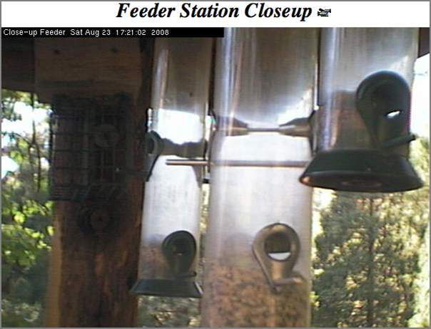
Robocam ...
Robocam ...
08.23.2008 20:10
PLATO computer system
I was talking to Capt Ben yesterday
and he mentioned that he got to try a system called PLATO back in
school. His description was pretty impressive. I had to check it
out and of course it is on wikipedia:
PLATO was the first (circa 1960, on ILLIAC I) generalized computer
assisted instruction system. It was widely used starting in the early
1970s, with more than 1000 terminals worldwide. PLATO was originally
built by the University of Illinois and ran in four decades, offering
elementary through university coursework to UIUC students, local
schools, and more than a dozen universities.
.
The project was later taken over by Control Data Corporation (CDC),
who built the machines it ran on at the University. CDC President
William Norris planned to make PLATO a major force in the computing
world, and was a keystone of his ideas about corporate social
responsibility. Although the project was economically a failure and
supplanted by other technologies by the time the last production PLATO
system was turned off in 2006, PLATO nevertheless pioneered key
concepts such as online forums and message boards, online testing,
email, chat rooms, picture languages, instant messaging, remote screen
sharing, and multi-player online games.
.
The acronym PLATO stands for Programmed Logic for Automated Teaching
Operations.
...
In 1972 a new system named PLATO IV was ready for operation. The PLATO
IV terminal was a major innovation. It included Bitzer's orange plasma
display invention which incorporated both memory and bitmapped
graphics into one display. This plasma display included fast vector
line drawing capability and ran at 1260 baud, rendering 60 lines or
180 characters per second. The display was a 512x512 bitmap, with both
character and vector plotting done by hardwired logic. Users could
provide their own characters to support rudimentary raster
graphics. Compressed air powered a piston-driven microfiche image
selector that permitted colored images to be projected on the back of
the screen under program control. The PLATO IV display also included a
16-by-16 grid infrared touch panel allowing students to answer
questions by touching anywhere on the screen.
...
08.23.2008 10:47
Seismic air guns and whales in the Gulf of Mexico
Oil,
Gas Seismic Work Not Affecting Gulf Sperm Whales, Study Shows
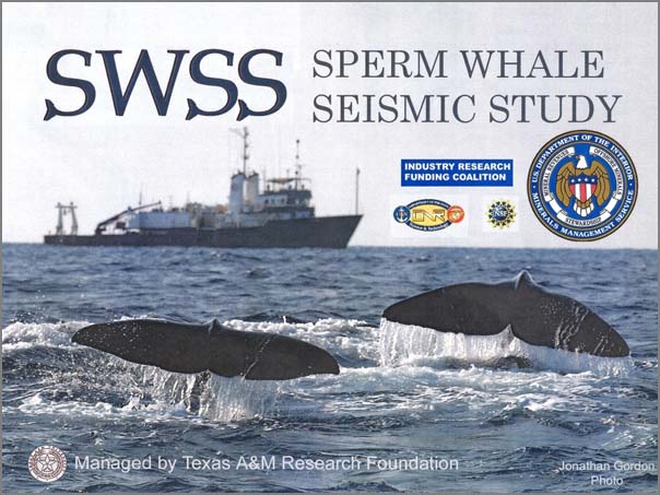
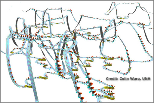
I'm having trouble tracking down the original source material on this one. I couldn't find any papers listed on the two researchers' web pages for this. I only found some reports on the project web page: The Sperm Whale Seismic Study (SWSS) [tamu] In looking through their report, I didn't see any visualizations of the whale behavior. I would hold judgement on these until that kind of work has been done. For example, Colin Ware has created TrackPlot to create ribbon plots from DTAG data (suction cup tags put on whales).
I can also offer a paper on which I am co-author to show other ideas for looking at acoustic impacts on whales: Hatch el al 2008 - Characterizing the Relative Contributions of Large Vessels to Total Ocean Noise Fields: A Case Study Using the Gerry E. Studds Stellwagen Bank National Marine Sanctuary, Environmental Management. Remember that this is just the priliminary paper. There is much more to come.
EPESC 2007 Report [pdf - spe.org]
...
The multi-year $9 million study, the largest of its type ever
undertaken and formally titled Sperm Whale Seismic Study in the Gulf
of Mexico, was conducted by the Minerals Management Service and
featured cooperation with the Office of Naval Research, the National
Science Foundation and the National Fish and Wildlife Foundation. The
project brought together researchers from eight universities, but it
was managed overall by Texas A&M's Department of Oceanography, with
research scientist Ann Jochens and professor Doug Biggs serving as
principal investigators.
.
"The bottom line is that airgun noise from seismic surveys that are
thousands of yards distant does not drive away sperm whales living in
the Gulf," Biggs explains.
.
"However, some individual whales feeding at depth reduced the rate at
which they searched acoustically for their prey when scientists
carried out controlled exposure experiments by bringing seismic
surveys close by the whales. As a result, the oil and gas industry has
agreed to a best-practice attitude that seismic surveys should shut
down temporarily when towed airguns come within one-third of a mile of
whales or groups of whales in the Gulf."
...
I'm having trouble tracking down the original source material on this one. I couldn't find any papers listed on the two researchers' web pages for this. I only found some reports on the project web page: The Sperm Whale Seismic Study (SWSS) [tamu] In looking through their report, I didn't see any visualizations of the whale behavior. I would hold judgement on these until that kind of work has been done. For example, Colin Ware has created TrackPlot to create ribbon plots from DTAG data (suction cup tags put on whales).
I can also offer a paper on which I am co-author to show other ideas for looking at acoustic impacts on whales: Hatch el al 2008 - Characterizing the Relative Contributions of Large Vessels to Total Ocean Noise Fields: A Case Study Using the Gerry E. Studds Stellwagen Bank National Marine Sanctuary, Environmental Management. Remember that this is just the priliminary paper. There is much more to come.
EPESC 2007 Report [pdf - spe.org]
In the Gulf of Mexico, sperm whales forage for deep-living prey in
continental margin areas that are receiving increasing human effort in
exploration for and production of oil and gas. Because these
endangered species use echolocation "clicks" to search for their prey
at depths of 500-2000 m, federal regulatory agencies have expressed
concern that sperm whales may be impacted by anthropogenic noise
produced by geophysical seismic surveys. To address this concern, TAMU
scientists based in College Station and Galveston worked in
partnership during summers 2002- 2005 with colleagues from seven other
universities for a cooperative study of sperm whales, their habitat in
the Gulf of Mexico, and their response to man-made noise.
.
Our cooperative Sperm Whale Seismic Study (SWSS) was sponsored by the
Minerals Management Service in cooperation with the Industry Research
Funders Coalition (IRFC), National Science Foundation (NSF), and
Office of Naval Research (ONR), with additional support provided by
the National Fish and Wildlife Foundation (NFWF). This study was
conducted in cooperation with scientists from Oregon State University
(OSU), Woods Hole Oceanographic Institution (WHOI), Scripps
Institution of Oceanography (SIO), University of Colorado (CU),
University of South Florida (USF), University of Durham (UD),
University of St. Andrews (UStA), and a UK small business venture
called Ecologic Ltd. A Science Review Board was established to provide
review and comment on the Summary Report for 2002-2004 and the
project's final Synthesis Report. This board consisted of five
members: one from the federal government (NOAA), one from industry,
one retired from the Marine Mammal Commission, and two from the
academic community. All activities involving sperm whales were
performed under the terms of valid permits from NOAA Fisheries.
...
08.22.2008 13:13
night run
Would be good to do a geozui
nighttime simulation of the this location to contrast with the
movie of an actual night run through a harbor. I also didn't know
that flickr can do movies.
http://www.flickr.com/photos/oneeighteen/2733197801/

Found through: Running The Houston Ship Channel - At night [gCaptain]
http://www.flickr.com/photos/oneeighteen/2733197801/
Found through: Running The Houston Ship Channel - At night [gCaptain]
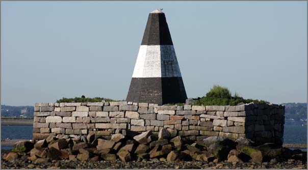
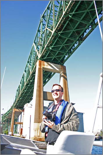
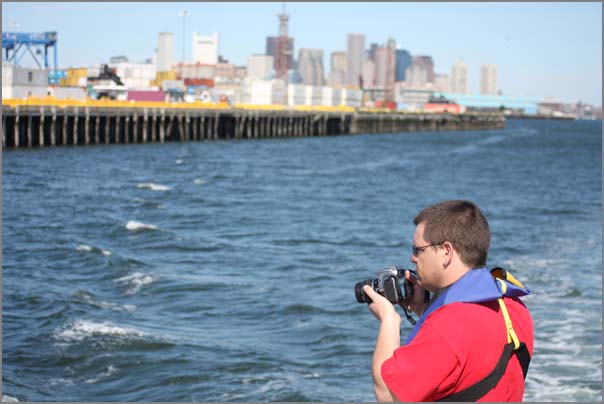
08.21.2008 13:31
Boston photo survey
Matt and I spent all of yesterday
doing a photo survey of much of Boston Harbor. We put on about 100
miles and took over 3000 photos. I think we both have sore arms
from the cameras. We had along two Cannons. Matt had the big zoom
lens, I had the wide angle. The goal was to get all of the key
features that a mariner might use for navigation. Things like
this:
Matt under the 1 bridge:
Matt in action just around the corner from the Constitution...
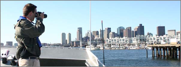
Kurt in action...
We made it to many of the corners of the harbor.
Matt under the 1 bridge:
Matt in action just around the corner from the Constitution...
Kurt in action...
We made it to many of the corners of the harbor.
08.19.2008 10:41
CODA underwater inspection system
The Underwater
Inspection System (UIS) [CodaOctopus] seems to be an AUV
Which patents? Is this just the standard multibeam processing? It's not clear how this compares to the work done by NASA with martian spacecraft or by Yuri at CCOM (which is more images). Automated generation of geo-referenced mosaics from video collected by deep submergence vehicles... [PDF]
From: Underwater Anti-Terrorism Technology for SF Bay [HydroInternational]
...
Using patented 3D mosaicing techniques, large areas can be
inspected very quickly and integrated into an intuitive geo-referenced
visualisation of the whole underwater scene in real-time, in the
murkiest of waters.
...
Which patents? Is this just the standard multibeam processing? It's not clear how this compares to the work done by NASA with martian spacecraft or by Yuri at CCOM (which is more images). Automated generation of geo-referenced mosaics from video collected by deep submergence vehicles... [PDF]
From: Underwater Anti-Terrorism Technology for SF Bay [HydroInternational]
Coda Underwater Inspection System (UIS), developed in
co-operation with the US Coast Guard, has been purchased by the
Sheriff's Office of Contra Costa County (CA, USA). The authority will
be the first on USA's West Coast to permanently deploy the UIS,
developed after the 9/11 attacks to address the need for a new
generation of port security technology to respond to underwater
threats.
...
08.18.2008 19:36
Two more Healy blogs
The Exploratorium has a section about
arctic regions: Ice Stories,
Dispatches from Polar Scientists:
Kevin Fall and Phil McGillivary are on the Healy and blogging.
Kevin Fall and Phil McGillivary are on the Healy and blogging.
08.15.2008 08:47
Updates from the Healy
Some updates from the Arctic...
Monica has a blog post up from on the ship: Healy Cruise - update 1
Val sent along this photo taken during the helicopter ride out to the Healy:
Monica has a blog post up from on the ship: Healy Cruise - update 1
Val sent along this photo taken during the helicopter ride out to the Healy:
08.13.2008 19:20
CCOM crew in on the Healy
Just got word that the CCOM crew is
onboard the USCG Healy ice breaker. They transited by helo...
always fun.
08.13.2008 17:54
Passing arrangements?
This is a few years ago, but
wow.
Incident Photo of The Week - Head On Collision [gCaptain / CargoLaw]
Incident Photo of The Week - Head On Collision [gCaptain / CargoLaw]
08.13.2008 11:28
LaTeX error messages
I'm not sure what is going on with my
LaTeX document...
pdflatex/natbib: \pdfendlink ended up in different nesting level than \pdfstartlink
<Figures/santabarbC_bath-v6.pdf, id=279, 451.6875pt x 325.215pt>
<use Figures/santabarbC_bath-v6.pdf> [6
! pdfTeX error (ext4): \pdfendlink ended up in different nesting level than \pd
fstartlink.
<to be read again>
                   \endgroup \set@typeset@protect
l.633
!  ==> Fatal error occurred, the output PDF file is not finished!
Transcript written on seismic-py.log.
make: *** [force] Error 1
This happens when I add a \cite{swig} later in my document, but not
early on. My bib entry isn't that interesting:
@article{swig,
  title = {Feeding a Large--scale Physics Application to Python},
  author = {D M Beazley and P S Lomdhal},
  year = {1997},
  journal = {International Python Conference},
  volume = {6},
}
I really like the way LaTeX does so many things, but its error
reporting is often beyond me. At least the great google
knows...pdflatex/natbib: \pdfendlink ended up in different nesting level than \pdfstartlink
I've found that pdflatex from tetex 1.0.7 aborts when natbib
author-name citations are split across a page boundary in twocolumn
mode.  I've attached a test case and the output.
.
Heiko Oberdiek confirms that the same thing happens with TeXLive 6 and
pdfTeX 1.00a.  For technical reasons, he expects that it will be very
difficult to fix.
.
Of course, the workaround is to adjust the spacing or linebreaking to
avoid the troublesome linebreak.  However, this can be difficult
because no PDF output is generated when pdflatex aborts, and the error
message does not list the line or section of the source file that
would need to be changed.
.
Luckily, there's a solution: when this error occurs, write down the
page number where pdflatex aborted, then add the "draft" option to
hyperref:
.
  \usepackage[draft]{hyperref}
In draft mode, I see that this reference puts a later citation over
a boundary. That was some serious frustration. Time to finish the
paper in draft mode and then see if I get lucky. Otherwise, I will
be adding some padding or figuring out how to prevent LaTeX from
splitting particular references. I was sure I was doing something
dumb in my BibTeX file. Nice to know that I was doing the right
thing.08.12.2008 10:00
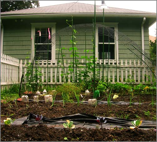
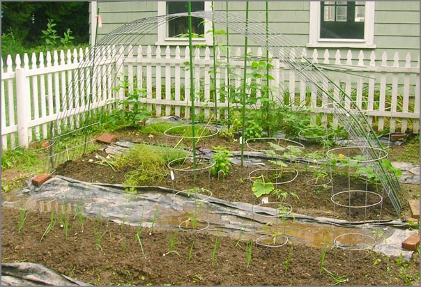
Gardening - protection for seedlings
Something has been taking out my peas
and beans as they start. Time to bring out the plastic bottles to
give them at least a chance. If the front, you can see some of the
cabages that I'm giving a go. Only Walmart had anything and
starting this late in the summer, I don't think the chances are
good.
08.11.2008 09:21
USCG in the arctic
Coast Guard Unprepared for Climate Change in Arctic [An
Unoffical Coast Guard Blog] points to
Coast Guard Unprepared for Climate Change in Arctic [National
Defense Magazine]
...
The United States must take a two-pronged approach of matching
strength with strength and engaging the Russians diplomatically. It is
doing neither, Borgerson said.  Denmark, Finland, Norway and Iceland
are also eying the region, and Canada is spending billions to build a
fleet to patrol arctic waters.
...
For now, the Coast Guard is doing what it can to discover what is out
there. Last fall the Coast Guard started "arctic domain awareness"
flights to get a feel for traffic patterns, as well as to monitor
foreign vessels to ensure they don't take fish in U.S. territorial
waters, Brooks said.
...
And in a report last February, the U.S. Polar Operations and Policy
Work Group identified problem areas and made a series of
recommendations including enhancing national security, projecting a
U.S. presence and protecting sovereignty.
...
A team from here at CCOM leaves this week to continue the Law of the Seas mapping of the Arctic using the Healy. Note that the US has as of yet signed the treaty.
08.10.2008 07:53
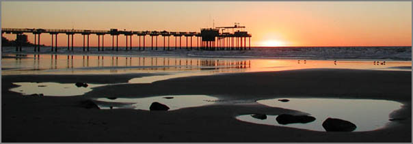
Scripps Pier
Here is an image I just ran into in
my photo collection. I took this 30-Jan-2002 while working on a
paper about the deformation in the Ardath shale that crops out on
the cliff here. Monica, Roxie, and Priyantha were on this beach
yesterday.
08.10.2008 07:50
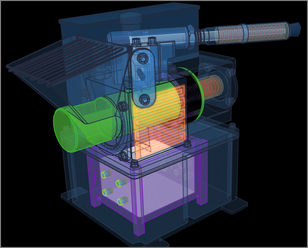
Phx WCL model
Mike Stetsion did an amazing job with
the Phoenix Wet Chemistry Lab (WCL)
08.10.2008 07:39
Standards for Nautical Pubs
I knew about S-100 effort, the update
to S-57, to make a XML format for Electronic Navigation Charts
(ENC), but I hadn't looked into the standards bodies web pages to
see what is going on. There are some interesting papers.
Standardization of Nautical Publications Working Group (SNPWG) for the CoastPilot. This is a part of Committee on Hydrographic Requirements for Information Systems (CHRIS)
For example, Jeppesen - BSH Pilot Study Report: [9th meeting]
Standardization of Nautical Publications Working Group (SNPWG) for the CoastPilot. This is a part of Committee on Hydrographic Requirements for Information Systems (CHRIS)
For example, Jeppesen - BSH Pilot Study Report: [9th meeting]
This project involved review of selected BSH publications, mapping
selected sailing directions content to the SNPWG8.x object model,
definition of a Jeppesen XML model, content conversion, and production
of sample outputs.  BSH had re-structured the content to support the
SNPWG model. They translated the content to English, and provided
background materials. The pilot team mapped the SNPWG/S57 object model
to the sailing directions content.  Jeppesen defined an XML model, XSL
code, and steel-thread processes to convert the BSH source content
from MS Word into an XML repository.  Jeppesen defined print, web, and
data extract output formats, and additional transforms and processes
were developed to move data from the repository into the 3
outputs. BSH reviewed and approved version 1 outputs, then updates
were applied in the XML model, and Jeppesen produced a version 2 print
sample.
.
Groundwork for the pilot started in Hamburg, Germany in October
2007. Earnest preparation started in November. The first project
outputs were reviewed in February, and the team drafted these findings
in March.
.
The pilot concludes that it is feasible to apply the SNPWG/S57 model
to the sailing directions sample and use the Jeppesen XML solution to
produce print, web, and data extract encapsulations that preserve the
BSH content. Caveats:
 * This mapping of SNPWG/S57 object model to the BSH Handbook was
   defined by the pilot team, and has not been validated by SNPWG.
 * We chose SNPWG/S57 objects that best fit the BSH SD text; we did
   not evaluate whether these also best fit the BSH implementation of
   ENCs.
 * Some content in the sample text was unique to text document
   formats, and not a clear candidate for chart object attribution;
   the Jeppesen XML handles both, but this is beyond the SNPWG/S57
   model.
The pilot study suggests that with diligent follow-through, publications products
that begin to implement the SNPWG/S57 model could be introduced in advance
0f the 2011 milestone for S-100. This can make S-100 stronger and soften the
impact of introducing S-100 for both the public and private sectors.
SNPWG meeting. All 3 outputs provide useful evidence on what is
08.09.2008 22:17
GeoDjango merged into Django mainline
This is great/big news! I didn't
realize GeoDjango was going to
be merged into the mainline Django so soon.
First baby-steps in GeoDjango
From the GeoDjango site:
First baby-steps in GeoDjango
For a couple of days now, Django trunk finally also includes
GeoDjango. A geo-spatial extension module for Django that adds --
among other things -- model fields and managers to easily use backends
like the geo-spatial extensions for PostgreSQL, MySQL and
Oracle. Let's see, how hard it is to get it going on my little
MacBook.
...
Too bad the author talks about MacPorts instead of fink
From the GeoDjango site:
GeoDjango was merged to trunk on 5th August 2008!
08.09.2008 11:22
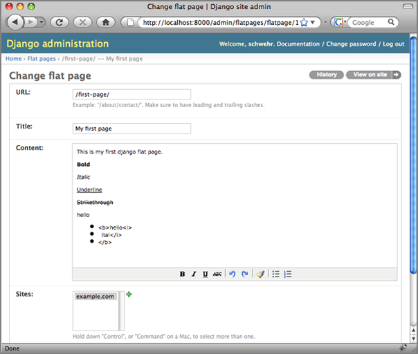
Practical Djano Projects
I've got a copy of Practical Django
Projects and am working through it. This book is a bit challenging
for people like me who don't have the time to really dig in deep
into the topic, but it is good. The book drops you into django very
quickly. In the first 3 chapters (25 pages), the book has you with
a working website using static Flatpages and even has you editing
the default Admin pages to at the JavaScript based TinyMCE editor to the flatpages
Admin edit.
08.09.2008 11:17
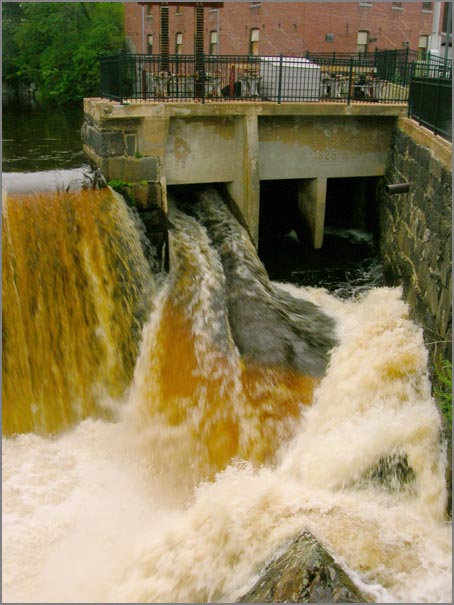
Rain and gardening
It's been raining quite a bit. We got
something like two inches in the last two days. I had to add some
drainage to the lake (err... garden). Here is the waterfall in
Newmarket yesterday.
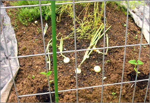
The garden is starting to come along. I've eaten some basil and onions from the garden so far.
I've been starting the next round of vegies. Hopefully it is not too late. Here are the first onions finishing up and two beans just planted.
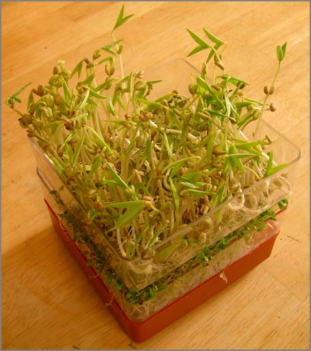
The folks got me the makings for sprouts. Next batch I will put less in there. I can't consume them as fast as they are growing.
The garden is starting to come along. I've eaten some basil and onions from the garden so far.
I've been starting the next round of vegies. Hopefully it is not too late. Here are the first onions finishing up and two beans just planted.
The folks got me the makings for sprouts. Next batch I will put less in there. I can't consume them as fast as they are growing.
08.09.2008 09:58
Stellwagen Bank National Marine Santuary management plan comment period
Public Comment Period Extended
NOAA's Office of National Marine Sanctuaries has extended the period
for public comment on the draft management plan and draft
environmental assessment for Gerry E. Studds Stellwagen Bank National
Marine Sanctuary (SBNMS) to Oct. 3, 2008. The original 90-day public
comment period, during which eight public hearings were held
throughout New England, was scheduled to end on Aug. 4, 2008. Comments
on the draft management plan and draft environmental assessment will
now be considered if received on or before Oct. 3, 2008, and may be
submitted by mail, emailed to sbplan@noaa.gov, or faxed to
781-545-8036.
.
The draft plan offers a detailed look at the current state of the
Stellwagen Bank National Marine Sanctuary and focuses on key issues
affecting the sanctuary, including ecosystem-based sanctuary
management, ecosystem alteration, wildlife disturbance, vessel traffic
and its potential threat to marine mammals, water quality and invasive
species. The plan also addresses important sanctuary programs such as
maritime heritage preservation, conservation science, enforcement,
interagency cooperation, public outreach and education, and
infrastructure development.
.
For a copy of the draft management plan and draft environmental
assessment, contact the Management Plan Review Coordinator, Stellwagen
Bank National Marine Sanctuary, 175 Edward Foster Rd., Scituate, MA
02066. Copies can also be downloaded from the sanctuary Web site at
http://stellwagen.noaa.gov.
.
Recruitment for new members on sanctuary's advisory council The SBNMS
is seeking applicants for the newly vacant Conservation (Member) seat
on its Sanctuary Advisory Council (Council) as well as the alternate
seat for the At-Large member.  Application packages are available at
the sanctuary website,
http://stellwagen.nos.noaa.gov/management/welcome.html or can be
obtained by contacting Elizabeth.Stokes@noaa.gov or at (781)
545-8026. Ext. 201. Application packages must be received by close of
business day 15 September 2008 at Stellwagen National Marine Sanctuary
Office, 175 Edward Foster Road, Scituate, MA 02066; faxed to
781-545-8036; or emailed to Elizabeth.Stokes@noaa.gov.
08.08.2008 20:38
Copyright - the current weird state
Under the current US copyright rules,
my blog is copyright protected until at least 2074 and possibly
until 2124 or so (depending on how long I live. Does that make
sense?
How copyright got to its current state (Patry blog ending)
What would the world of computer software be like if we had even stronger copyright protections, but they only lasted 14 years?
William Patry, one of the most respected online commentators on
copyright, has shut down his weblog. His parting observation is stated
in the personal, non-analystical style he liked to cultivate online,
but it will serve as a declaration of policy (as well as a cry of
protest) among artistic and technically creative people for some time
to come:
.
    The Current State of Copyright Law is too depressing
...
The powerful individual inclination toward control of copyrightable
material has resulted in political pressure for the strengthening of
copyright protection. In fact, the story of copyright from the 1700s
until about 1990 has been almost entirely a story of lengthening terms
(from 14 years to life plus 70 years), increasing scope (from only
particular types of works to almost all works), and stronger
protections (from restrictions on publishing rights only to
restriction of almost all uses).
...
Now imagine the world where the blog and all the software I wrote
was only protected for 14 years. That means that all the software I
wrote in the 1st 4 years of undergrad would be public domain. The
first software I wrote for a Marsokhod (do you even know what the
Marsokhods are?) would have 2 more years to go. That would be code
written for VxWorks VWMare 4.x on a 68030. In the computer world,
that is the dark ages (and a world I'd rather not revisit).What would the world of computer software be like if we had even stronger copyright protections, but they only lasted 14 years?
08.08.2008 12:02
Python at AGU
Too bad I'm not into hydrology! AGU
has a section called:
H17: Python Application in Hydrology
Python is rapidly becoming one of the main tools in the toolbox of
many hydrologists. Python is used for linking models, visualization,
data analysis, pre and post processing of model data, computational
mathematics, time series analysis, and many other tasks. In addition,
it is very attractive for educational purposes. Python is a free and
open-source computer language. Some of its main features include a
clear and powerful syntax, a large collection of packages (libraries)
and an active, helpful, open-source community. In this session, we
seek to provide a representative overview of existing applications of
Python in the hydrological sciences, to form a hydrological community
of Python aficionados, and to demonstrate a critical mass. Above all,
we want to show that Python is an excellent choice for the development
of software for the solution of both small and large scale
hydrological problems.
08.08.2008 07:24
PTP IEEE 1588 timing protocol for hydrographic work
Just out today:
Innovation in High-precision GNSS Timing Products [Hydro
International]
NovAtel Inc. and Brilliant Telecommunications Inc. have signed a
technology partnership agreement to develop and deliver innovative
timing, synchronization and positioning solutions. The companies will
undertake cooperative development activities, combining their
respective technologies to create new product platforms that target
high precision applications.
.
"GPS and GNSS precise positioning technology is a key element to meet
the growing demands placed on Network Time Protocol (NTP) and
Precision Time Protocol (PTPv2) server technology, as the end-to-end
transmission and synchronisation of voice, data and video across
packet-based networks becomes more sophisticated," said Jon Ladd,
NovAtel's Chief Executive Officer.
...
If you are interested in high precision timing, you should first read Brian Calder, Rick Brennan, et al. 2007: Application of High-Precision Timing to Distributed Survey Systems [pdf]
Abstract
In any hydrographic survey system that consists of more than one
computer, one of the most difficult integration problems is to ensure
that all components maintain a coherent sense of time. Since virtually
all modern survey systems are of this type, timekeeping and
synchronized timestamping of data as it is created is of significant
concern. This paper describes a method for resolving this problem
based on the IEEE 1588 Precise Time Protocol (PTP) implemented by
hardware devices, layered with some custom software called the
Software Grandmaster (SWGM) algorithm. This combination of hardware
and software maintains a coherent sense of time between multiple
ethernet-connected computers, on the order of 100 ns (rms) in the best
case, of the timebase established by the local GPS-receiver clock.
.
We illustrate the performance of this techniques in a practical survey
system using a Reson 7P sonar processor connected to a Reson 7125
Multibeam Echosounder (MBES), integrated with an Applanix POS/MV 320
V4 and a conventional data capture computer. Using the timing
capabilities of the PTP hardware implementations, we show that the
timepieces achieve mean (hardware based) synchronization and
timestamping within 100-150 ns (rms), and that the data created at the
Reson 7P without hardware timestamps has a latency variability of 28
micro-s (rms) due to software constraints within the capture system.  This
compares to 288 ms (rms) using Reson's standard hybrid
hardware/software solution, and 13.6 ms (rms) using a conventional
single-oscillator timestamping model.
08.07.2008 14:57
LRIT on vessels
First
Ship with LRIT Compliance
 International Tanker Management (ITM) managed and Marshall
Islands flagged tankers MT PORT LOUIS, MT ALTIUS and the bulker MV
PORT MELBOURNE reported that they have became the first vessels to be
officially issued with LRIT Conformance Test Report Certification
following the successful shipborne equipment conformance testing of
the vessels' Inmarsat C equipment. ...
08.07.2008 14:08
Computer security and the US President
Memo to Next President: How to Get Cyber Security Right by
Bruce Schneier
...
Spread those research dollars wide. Lately, most research money has
been redirected through DARPA to near-term military-related projects;
that's not good. Keep the earmark-happy Congress from dictating (.pdf)
how the money is spent. Let the NSF, NIH and other funding agencies
decide how to spend the money and don't try to micromanage. Give the
national laboratories lots of freedom, too. Yes, some research will
sound silly to a layman. But you can't predict what will be useful for
what, and if funding is really peer-reviewed, the average results will
be much better. Compared to corporate tax breaks and other subsidies,
this is chump change.
.
If our research capability is to remain vibrant, we need more science
and math students with decent elementary and high school
preparation. The declining interest is partly from the perception that
scientists don't get rich like lawyers and dentists and stockbrokers,
but also because science isn't valued in a country full of
creationists. One way the president can help is by trusting scientific
advisers and not overruling them for political reasons.
...
08.07.2008 06:27
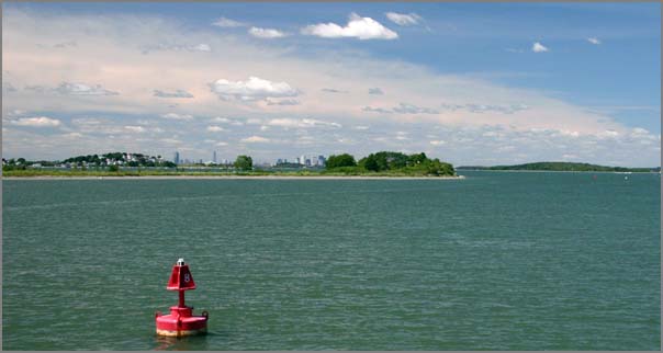
Oil spill buoy
Prototype of robotic buoy developed to fight maritime pollution
[Japan Today]
Robot buoy to track oil spills [primidi.com]
I can't find any other pictures, so here is the same one that all the websites are showing...
Robot buoy to track oil spills [primidi.com]
...
This robot buoy has been designed by Naomi Kato, professor of
submersible robotic engineering at the Department of Naval
Architecture at Osaka University, Japan, with the members of his
lab. The 'Katolab' "is conducting education and research on underwater
robotics, biomechanics on aquatic animals and its application to
engineering, computational hydrodynamics of viscous flow fields."
...
Development of Spilled Oil Autonomously Chasing Buoy System [Creator's website - Kato Lab]
I can't find any other pictures, so here is the same one that all the websites are showing...
08.06.2008 16:25
NOAA Rainier launches
CCOM just had two researchers out
checking out these launches.
NOAA 4-Year Vessel Acquisition Plan [mtr]
NOAA 4-Year Vessel Acquisition Plan [mtr]
The design of the new launch is based on an evolution of the original
hull form designed for NOAA in 1975 and was updated by Jensen Maritime
Architects. This proven design features sturdy construction and a full
keel for survey work in poorly charted waters. Design updates include
an open working deck and 200 lb. capacity A-frame that can mount a
wide variety of equipment.  The propulsion package consists of a
Cummins QSC 8.3 liter 490-hp engine turning a 25"x26" ZF propeller
through a ZF 305 gear. Cruising speed is 24 knots and typical survey
speeds are approximately eight knots.  The multi-mission designed
boats are equipped with a state-of-the-art hydrographic surveying
suite, including dual frequency Reson 7125 multibeam sonar, Applanix
POS MV positioning and attitude sensor, and a Brooke Ocean MVP-30
moving vessel profiler.
08.06.2008 15:55
Marine navigation ontologies
I'm re-reading XML Encapsulation of
Navigation Typography by John Tucker and John Nyberg [Hydro
2005]. John^2 mention some work by Raphael Malyankar that I have
not yet looked into. This project looks very interesting and
looking at the papers, I realized that our GeoCoastPilot
project draws on this research
Representation, Distribution and Ontologies for Geospatial Knowledge [ASU]
Representation, Distribution and Ontologies for Geospatial Knowledge [ASU]
This project is creating a computational ontology that will facilitate
the creation of software that understands the meaning of geographical
features.  The most sophisticated geographical information systems
(GIS), ENC (Electronic Navigational Chart) systems, and digital
cartographic systems currently available still contain only very basic
geospatial information, for example, representations of routes and
waypoints, tide tables, currents, overlays of one kind or
another. Further, they are capable of only relatively basic geographic
operations, for example, distance, adjacency, Voronoi diagrams,
etc. Smarter processing of geospatial information is needed, giving
software the ability to understand what geospatial entities `mean', so
that it is possible for a navigational program to understand, for
example, that shorelines can be crossed by aircraft but not by surface
vessels, that tidal tables are important for near shore navigation,
that routes may need to stay away from restricted waters, that cutting
across shipping lanes should be minimized, etc. Future plans for this
research include ontologies for other kinds of geospatial knowledge.
08.06.2008 09:48
NOAA and Navy test marine mammal reactions to Navy Sonar
Scientists
Use Naval Exercises to Learn More About How Marine Mammals React to
Sonar [noaa]
...
Scientists used the naval military exercises, hosted biennially by the
U.S. Pacific Fleet, as an opportunity to learn more about deep-diving
whales and how they might respond to military sonar in their
environment. RIMPAC includes the use of mid-frequency active sonar for
anti-submarine warfare training in various areas around
Hawaii. Transmissions were not directed at marine mammals for the
study. Scientists and the Navy used mitigation measures to minimize
exposure to nearby mammals.
.
Dr. Brandon Southall, director of NOAA's Ocean Acoustics Program and
co-funder of the project says that this study has already produced
major advances, including ground-breaking measurements of basic
biological factors, such as increased data on individual
animals. Although this area of study is relatively new and
challenging, scientists around the world are developing sophisticated
technologies, and partnering to learn more about how human sounds
affect marine mammals.
.
"The study of marine mammal acoustics and behavior is an area of
emerging interest for many reasons, but there have been many recent
advances, including this recently completed study" Southall said. "We
were fortunate to have some of the best scientists in these fields
working with NOAA on this pilot project. It will take some time to
analyze the data and see what conclusions may be drawn, but in many
ways this effort lays the foundation for more sophisticated
collaborative efforts in the future."
...
08.05.2008 17:31
Nahant, MA
Today, we had lunch just north of
Boston on a little peninsula called Nahant at Tides.
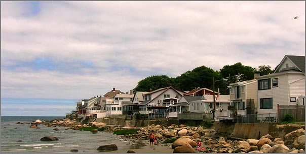
A quick drive around yielded all sorts of amazing houses.
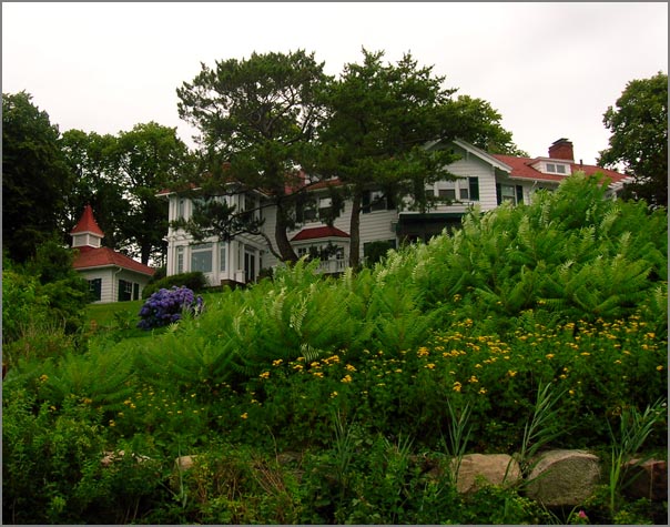
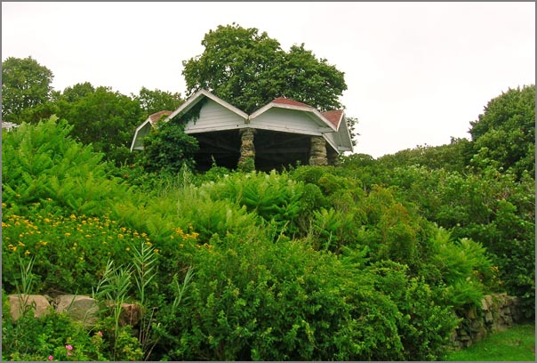
Tucked away at the far end of the island is the Northeastern University's Marine Science Center (MSC). They have some nice buildings and amazing grounds, but this building is more of a bunker. Kinda cool looking place to work.

A quick drive around yielded all sorts of amazing houses.
Tucked away at the far end of the island is the Northeastern University's Marine Science Center (MSC). They have some nice buildings and amazing grounds, but this building is more of a bunker. Kinda cool looking place to work.
08.05.2008 08:40
First AIS problem report to the USCG
Earlier this year, the USCG said that
nobody had reported any problems with AIS to them. I finally got
around to submitting my first problem. My software had the faulty
assumption that a vessel name in msg 5 always had at least one
character. Then, last night, my daemon crashed.
My code now handles vessels with empty name fields. In python, I now use name.strip('@ ') in one more place.
NAME for 366981240 is ""I went to http://www.navcen.uscg.gov/ado/ais_form.asp and submitted a report. I should really get around to reporting the two government vessels using a MMSI/UserID of 0 in the boston area.
My code now handles vessels with empty name fields. In python, I now use name.strip('@ ') in one more place.
08.04.2008 15:00
Marine marine mammal tag download NOAA system request
Thanks to Andy A. for pointing us to
this...
Develop a System and Build Prototype to Download Dive and GPS Location Information from Telemetry Tags - Solicitation Number: WRAD-8-838
Develop a System and Build Prototype to Download Dive and GPS Location Information from Telemetry Tags - Solicitation Number: WRAD-8-838
...
This project will involve the development of a prototype VHF/UHF/GSM
receiving station that can archive data transferred from telemetry
devices deployed on marine mammals. The recipients of this contract
will work in conjunction with NMFS staff and other partners on the
construction of this station using existing technologies. The final
product should be able to receive and store data from standard
dive/gps location tags deployed on marine mammals such as the Wildlife
Computers MK10 satellite tag or Sea Mammal Research Unit GPS/GSM
tag. Some existing tags utilize UHF or GSM, but designers of the
prototype should consider all options for transmitting/receiving
archived data. The ultimate goal, beyond the scope of this contract is
a station that is portable, robust and able to be deployed in remote
areas and in a variety of climates.
.
Timeline: Sept 2008 - Aug 2010
.
Deliverables:
* Report on the strengths and weaknesses (including cost, bandwidth,
  range, power consumption etc.) of using VHF, UHF, GSM or other
  technology for the transfer of data to logging system. This should
  include a discussion of the feasibility of modifying existing
  telemetry tags to communicate with the tower.
* Schematics for a portable micro-tower high-bandwidth receiving
  stations with data-logging capabilities capable of recording data
  transmitted from a marine mammal telemetry tag using VHF, UHF, GSM
  or other technology.
* Reports on performance tests on various aspects of the technology
  including, but not limited to: data quality, range, power
  consumption, portability.
* Quarterly project reports that will include progress on development.
* Prototype receiving-archiving station.
...
08.04.2008 08:32
2007 AUV Competition Video
This last weekend in San Diego was
the annual AUV competition out at SPAWAR on Point Loma. Wish I was
there to see it, but I did find a video of last year's event. Sib
had me come along and help out one year while I was living in San
Diego. I had fun helping out for one day.
auv08v5final.mov
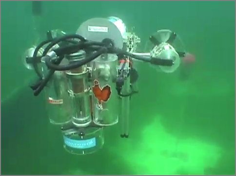
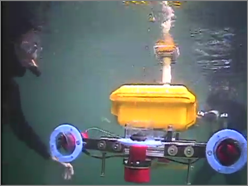
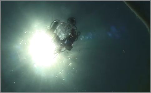
AUVSI Competition page
auv08v5final.mov
AUVSI Competition page
08.03.2008 23:01
python bitarray module
Just ran into a cPython bitvector
like project: bitarray by Ilan
Schnell. Doens't have a license stated in the files, but it is
interesting to see this implemented using the cPython
interface.
08.02.2008 13:25
Neal gets a grant to map San Diego Bay
Thanks to Monica for pointing me at
this article that includes quotes from Neal Driscoll (one of my PhD
committee co-chairs):
Scientists from two universities team up to map marine habitats in S.D. Bay [SignOnSanDiego]
Scientists from two universities team up to map marine habitats in S.D. Bay [SignOnSanDiego]
...
"There is a rich tapestry of sediment types and rocks on the sea floor
that give rise to a variety of biological habitats," said Neal
Driscoll, a Scripps professor involved in the project. "What we're
trying to do is better understand the link between geology and marine
biology."
.
This week, the center received a major boost when the San Diego Port
District's Environmental Advisory Committee voted unanimously to
recommend a grant of $301,000.
.
If the full seven-member Port Commission approves the grant as
expected on Sept. 2, the center's directors will be able to buy a
high-resolution, multibeam echo sounder for mapping the floor of San
Diego Bay.
...
08.02.2008 12:39
boost.python hello world on Mac OSX 10.5 with fink
I've been attempting to give a look
at the boost.python tool for adding a python interface to a C++
class. I'm trying a restart on creating a cBitVector class. I don't
know how to use bjam, so I'm not sure if there is an easier way to
do this. But I finally got at least something to work. I had
trouble with a missing init when the module name and shared object
file name did not match.
What I have installed from fink for this:
What I have installed from fink for this:
% fink list -i boost
Information about 7010 packages read in 0 seconds.
 i   boost-jam                3.1.16-1           Extension of Perforce Jam make replacement
 i   boost1.33-shlibs         1.33.1-1009        Boost C++ Shared Library Files
 i   boost1.34.python25       1.34.1-1004        Boost C++ Libraries: static and source libs
 i   boost1.34.python25-shli  1.34.1-1004        Boost C++ Libraries (shared libs)
There is the source file hello.cpp. I'm not a fan of .cpp for C++ code, but that was the tutorial's style.
char const* greet() {
    return "hello";
}
#include <boost/python.hpp>
BOOST_PYTHON_MODULE(hello)
{
    using namespace boost::python;
    def("greet",greet);
}
Build it the module. Here is the Makefile:
default:
        g++ -fno-strict-aliasing -Wno-long-double \
            -g -fwrapv -g -Wall \
           -I/sw/include/python2.5 -I/sw/include \
           -c hello.cpp -o hello.o
        gcc -L/sw/lib -bundle -undefined dynamic_lookup \
            hello.o -o hello.so -lboost_python
Now try it out...
In [1]: import hello
In [2]: hello. # Press tab here
hello.__class__     hello.__file__          hello.__name__      hello.__repr__    hello.greet
hello.__delattr__   hello.__getattribute__  hello.__new__       hello.__setattr__ hello.html
hello.__dict__      hello.__hash__          hello.__reduce__    hello.__str__     hello.o
hello.__doc__       hello.__init__          hello.__reduce_ex__ hello.cpp         hello.so
In [2]: hello.greet()
Out[2]: 'hello'
08.01.2008 16:48
eNav 2008
Michael Winkler pointed me to the
recently released schedule for eNavigation 2008 coming up in
November... 2008
Agenda. e.g.
- AIS Regulations, an update - Mr. Jorge Arroyo, U. S. Coast Guard
- Electronic Chart Systems; Where are things going, and will there be a domestic standard? And, if so, what should it be? - U.S. Coast Guard speaker
- An update of the status of Radio navigation systems (Loran and DGPS) - U.S. Coast Guard speaker
- The Coastal and River Information System: System goals, current status, future plans - Mr. Michael F. Winkler Research Hydraulic Engineer, U. S. Army Corps of Engineers
- The COSCO BUSAN Allision and its Aftermath- CDR Brian Tetreault, USCG. Chief, Vessel Traffic Services, U.S. Coast Guard
- Expanding the use of AIS within Vessel Traffic Services: Developing binary messaging to reduce voice communications and workload - Ms. Irene M. Gonin, U.S. Coast Guard Research & Development Center
08.01.2008 08:47
Me in the Anchor newsletter
The Anchor newletter this month has several articles that I
want to mention. There is one on the GeoCoastPilot and another on
the new Integrated Ocean and Coastal Mapping (IOCM) processing
center, in which I now physically reside. There is also a small
paragraph about me visiting a local chapter of the Boy Scout's
Order of the Arrow.